

Sedimentary-tectonic significance of the Silurian–Devonian basin filling sequence in the Shaerbuerti Mountain area, western Junggar
-
摘要:
新疆西准噶尔北部谢米斯台山—沙尔布尔提山地区是中亚造山带的重要组成部分。志留纪普里道利世—早泥盆世期间,该地区沉积了一套由海相复理石到陆棚碳酸盐岩转变的盆地充填序列,其沉积体系的时空展布、岩相变化以及物源分析可为重建西准噶尔北部古地理格局以及古亚洲洋演化提供证据。本文对沙尔布尔提山地区的芒克鲁Ⅱ剖面进行了详细的岩相分析、砂岩碎屑统计、主、微量元素分析,来探讨沉积盆地的演化过程、构造背景和物源属性。芒克鲁Ⅱ剖面出露乌吐布拉克组与曼格尔组,剖面由底到顶依次出现盆地—斜坡背景层沉积、盆地浊积岩、陆棚边缘的异重流扇、陆棚、浅水颗粒滩的相序列,表现为向上变浅的盆地充填序列。沉积物以砂岩、砾岩和生物碎屑颗粒灰岩为主。砂岩成分以长石、岩屑为主,成分变异指数ICV=1.37,值大于1,指示了碎屑岩成熟度低。砂岩样品富集大离子亲石元素(LILEs),亏损高场强元素(HFSEs),轻稀土与重稀土元素比值(LREEs/HREEs)在2.89~7.41,均值6.15。物源判别及构造判别图解综合显示其物源主要来自长英质火山岩及安山岩的混合源区,物源区以大陆岛弧与大洋岛弧环境为主。研究表明,谢米斯台山–沙尔布尔提山岛弧火山岩可能为盆地充填过程提供了丰富的物源,盆地浊积岩向陆棚异重岩沉积的转变不仅代表了盆地充填的暂时性终止,也有可能代表了沙尔布尔提山地区在这一时期的俯冲碰撞活动基本结束。
Abstract:The Xiemisitai-Shaerbuerti Mountain region, located in West Junggar, Xinjiang, China, represents an important part of the Central Asian Orogenic Belt (CAOB). From the Silurian Pridoli epoch to early Devonian, a set of basin filling sequence transitioning from marine flysch to shelf carbonate is deposited in this region. The spatial-temporal distribution of the sedimentary system and analyses of lithofacies and sources can provide evidence for reconstructing the paleogeographic configuration of western Junggar and the evolution of the Paleo-Asian Ocean. This study conducted a detailed analysis of lithofacies, sandstone clasts, as well as major and trace elements in the Mangkelu Ⅱ section of the Shaerbuerti Mountain area to explore the sedimentary basin's evolution, tectonic background, and provenance attributes. The Mangkelu Ⅱ section consists of the Wutubulake Formation at the bottom and the Mangeer Formation at the top. The facies successions from bottom to top includes slope–basin background deposits, basin turbidites, hyperpycnal flow fans at the shelf margin, shelf, and shallow sea grain shoal, representing an upward-shallowing basin-fill sequence. The main sediments are sandstone, conglomerate, and bioclastic limestone. The sandstone is mainly composed of feldspar and lithics, with an index of compositional variability (ICV) of 1.37, which is greater than 1, indicating low maturity. The sandstone samples are enriched in large ion lithophile elements (LILEs) and depleted in high field strength elements (HFSEs), with a ratio of light rare earth elements to heavy rare earth elements (LREEs/HREEs) ranging from 2.89 to 7.41, averaging 6.15. The provenance and tectonic discrimination diagrams show a mixed source of intermediate-felsic volcanic rocks and andesites, derived mainly from continental and oceanic island arcs. Volcanic rocks from the Xiemisitai-Shaerbuerti Mountain island arc provided abundant material for the basin fill. The transformation of sedimentary facies from turbidites to hyperpycnites in the continental shelf may represent a temporary termination of basin filling and the end of subduction and collision during this period in the Shaerbuerti Mountains.
-
Keywords:
- western Junggar /
- Silurian Pridoli epoch to early Devonian /
- flysch /
- lithofacies /
- provenance /
- island arc
-
0. 引言
2025年1月7日9时5分,西藏自治区日喀则市定日县发生Ms6.8级地震,震中位于28.50°N,87.45°E,震源深度10 km,最高烈度达到Ⅸ度,Ⅵ度区及以上面积约
23986 km2,共涉及西藏日喀则市定日县、拉孜县、定结县、昂仁县、萨迦县、岗巴县等6县45个乡镇。地震导致大量房屋倒塌、路基塌方、供水供电设施受损,截至2025年1月9日,地震已经造成126人遇难,188人受伤,约6.15万名群众不同程度受灾,紧急转移安置4.75万人。受印度板块推挤和地壳增厚等高原隆升效应影响,青藏高原边界主要以逆冲褶皱和走滑变形为主,但内部却发生近东西向的伸展变形,促使高原内部形成一系列呈近南北向和北东向的裂谷及相关的活动正断层,并构成高原内部的重要控震构造(图1;吴中海等,2015)。第四纪期间,北北东向伸展构造极为活跃,发生多次正断层型强震事件,形成地表破裂、错断地貌、大型滑坡等一系列同震遗迹(殷跃平等,2014;吴中海等,2015;田浩然等,2023;Zeng et al.,2020;李为乐等,2024;王运生等,2023;许强等,2025)。本次定日Ms6.8级地震发生在青藏高原内部发育的大型东西向伸展构造之一的申扎—定结裂谷附近(张进江等,2023),该区主要发育一系列南北走向的正断层,发震断裂为近南北向延伸的登么错正断层,兼有一定的走滑分量,断层活动在地表形成长达26 km的地表破裂带,垂直位错量可达3 m,是青藏高原内部东西向伸展构造持续变形的又一次证明。本次地震波及区域为高差巨大的高寒山区,从低海拔河谷盆地到高海拔冰雪覆盖区,局部地形高差超过
3000 m,该区高陡斜坡发育,冰川冰湖分布,发生于这种高寒环境的强震可能直接触发砂土液化、滑坡、崩塌、冰岩碎屑流和冰湖溃决等次生地质灾害(韩金良等,2009;殷跃平等,2011;李明辉等,2014;Fan et al.,2019;铁永波等,2024);与此同时,强烈的地震动会对一定范围内的地质环境造成强烈冲击,导致震区斜坡岩土体结构劣化,发生震裂、松弛等变形(张永双等,2016;金章东等,2022;Xi et al.,2024;高延超等,2024)。这种岩土体的劣化效应将长期影响震区地质灾害的发生频率。已有研究证明,地震过后山区崩塌、滑坡和泥石流等地质灾害易发程度及破坏性显著增强,地表物质侵蚀速率增加,活跃周期持续数十年之久,且震后次生地质灾害的群发性和链生效应突出,规模明显增大,对震区社会经济的可持续发展造成威胁(Fan et al.,2019;Chen et al.,2020;铁永波等,2022a;范宣梅等,2022;铁永波等,2022b;熊小辉等,2024)。因此,研究本次地震特征及同震地质灾害发育特征,不仅对震区灾害重建规划与地质灾害防治具有重要指导意义,而且对于揭示晚新生代青藏高原内部南北向构造变形机制、地震周期预测和评价该地区及其周边地区的未来地震危险性具有重大科学意义。![]() Figure 1. Distribution map of active faults in the Qingzang Plateau (after Bian et al., 2021; Liu et al., 2022)
Figure 1. Distribution map of active faults in the Qingzang Plateau (after Bian et al., 2021; Liu et al., 2022)此次研究主要聚焦定日县Ms6.8级地震影响区内已有和新增地质灾害分布规律及发育特征,在分析区域地质条件对地质灾害的控灾基础上,提出震区地质灾害的防灾减灾建议,为震区灾后重建规划与地质灾害防治提供科学依据。
1. 研究区概况
本次地震震中位于西藏日喀则市定日县措果乡附近,地处青藏高原南部,喜马拉雅山脉北麓,震中及邻近地区山峦起伏、沟谷纵横,平均海拔接近
4000 m,局部地形高差超过3000 m。该区宏观地貌以深大断裂为构造格架,盆岭走向为北北东—南南西向,整体呈现出一系列强烈侵蚀切割的高山与平缓谷地相间地貌,海拔从低到高依次发育河谷地貌、剥蚀低中山地貌、强侵蚀和剥蚀中高山地貌、以冰蚀为主的极高山地貌,其地貌形成过程与整个青藏高原的隆升和演化密切相关。震区地处喜马拉雅山脉北翼,气候类型属于高原温带半干旱季风气候,年降水量 319 mm,降水主要集中在七、八月份;地表水系以朋曲河水系为主,呈近东西向展布,受大气降水和融雪补给,水量充沛,但随季节变化波动较大。此外,震中北部及南部的高海拔地区发育大量冰川、石冰川、冰湖等地貌,为冰岩碎屑流、冰湖溃决、冰川泥石流等地质灾害的发育创造了有利条件。震区地层岩性复杂,广泛出露奥陶系(O)、志留系(S)、志留系(S)、泥盆系(D)、石炭系(C)、二叠系(P)、三叠系(T)、侏罗系(J)、白垩系(K)和第四系(Q),其中,以中生界三叠系和侏罗系沉积岩分布最广。震中区域下伏地层主要为三叠系和侏罗系的石灰岩、页岩、砂岩等沉积岩;河谷区域上覆第四系,主要分布在朋曲河及其支流的相邻区域内,包括更新世和全新世湖积相、冲积相及少量洪积相的松散沉积物,为地震时砂土液化的发生提供了物质条件。震中北部发育前寒武系拉轨岗日杂岩,主要为一套花岗片麻岩—黑云斜长片麻岩建造;震中南部同样发育一套前寒武系变质岩,主要包括片岩、片麻岩、石英岩、石英片岩、花岗闪长质–英云闪长质片麻岩等,岩体变质程度较强;侵入岩体主要为新生代花岗岩类,包括二云二长花岗岩、黑云母二长花岗岩、电气石白云母花岗岩等,伴随前震旦系变质岩零星产出。
本次地震位于喜马拉雅地块,雅鲁藏布江缝合带(IYS)以南、藏南拆离系(STDS)以北、尼玛—定日裂谷以东、申扎—定结裂谷以西,其中,南北向延伸的尼玛—定日裂谷和申扎—定结裂谷向北切割雅鲁藏布江缝合带,向南切割藏南拆离系并延入喜马拉雅,导致该地区地质构造复杂,但研究程度相对较低(吴中海等,2015)。晚新生代以来,在南北向挤压和青藏高原整体式隆升的构造背景下,高原内部东西向伸展变形显著,并在高原中南部广泛形成一系列呈南北走向的大型伸展构造,在构造形迹上表现为南北向的地堑和正断层,地貌上形成南北向延伸的狭长带状平缓谷地(图1)。地貌单元以正断层为分界线,山脉与谷地之间相对高度差达到数百甚至上千米,并发育一系列断层三角面、错断地貌、大型古滑坡等断裂活动遗迹(Zeng et al.,2020;Wang et al.,2024)。本次定日Ms6.8级地震发震断层为登么错正断层,位于尼玛—定日裂谷和申扎—定结裂谷之间,全新世活动性强烈,历史上曾发生过多次Ms5.0级以上地震(图2;侯丽燕等,2020;张小涛等,2020)。据国家地震台网中心发布数据,自1900年以来,该地区距震中50 km范围内Ms3.0级及以上地震共发生40次,其中3.0~3.9级地震25次,4.0~4.9级地震6次,5.0~5.9级地震7次,6.0~6.9级地震2次。在这些地震中,距本次地震时间最近的地震是2020年3月20日发生于西藏日喀则市的定日Ms5.9级地震,位于尼玛—定日裂谷带附近,两次地震震中相距仅15 km。
![]() 图 2 定日Ms6.8级地震烈度及历史地震分布图Figure 2. Seismic intensity of the Ms6.8 Dingri earthquake and catalog of the earthquakes around the study area
图 2 定日Ms6.8级地震烈度及历史地震分布图Figure 2. Seismic intensity of the Ms6.8 Dingri earthquake and catalog of the earthquakes around the study area2. 定日县Ms6.8级地震区地质灾害发育规律
2.1 震前地质灾害发育分布特征
根据西藏自治区地质灾害隐患点在库统计数据,此次震区5县境内共有地质灾害隐患点868处,从空间分布特征上看,震前地质灾害隐患点主要沿河流分布(图3)。灾害类型以泥石流为主,其中泥石流634处、滑坡104处、崩塌130处(表1)。灾害规模以小型和中型为主,其中小型555处、中型252处、大型60处、特大型1处。
![]() 图 3 震前地质灾害点分布图Figure 3. Distribution of geological disaster sites before the earthquake表 1 震区震前地质灾害点统计表Table 1. Statistical table of geological disaster points before the earthquake in earthquake area
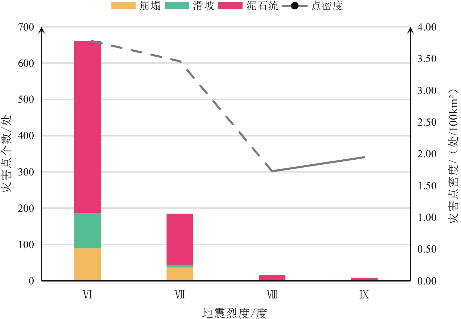
图 3 震前地质灾害点分布图Figure 3. Distribution of geological disaster sites before the earthquake表 1 震区震前地质灾害点统计表Table 1. Statistical table of geological disaster points before the earthquake in earthquake area县 泥石流/处 滑坡/处 崩塌/处 合计/处 拉孜县 226 9 26 261 定日县 156 10 36 202 定结县 73 77 51 201 昂仁县 123 6 17 146 萨迦县 54 2 0 56 岗巴县 2 0 0 2 合计 634 104 130 868 定日县Ms6.8级地震影响范围内,震前地质灾害发育,其分布密度与地震烈度无显著相关关系(图4)。在烈度为Ⅸ度区内,地质灾害点共8处,主要分布在长所乡附近。在烈度为Ⅷ度区内,地质灾害点共15处,主要分布在曲洛乡附近。在烈度为Ⅶ度区内,地质灾害点共185处,主要分布在定日县—曲洛乡段、拉孜县查务乡—芒普乡段、萨迦县麻布加乡、定结县城附近。在烈度为Ⅵ度区内,地质灾害点共660处,主要分布在定日县扎西宗乡、定日县周边、昂仁县卡嘎镇附近和马泉河沿线、拉孜县拉孜镇—彭措林乡段、萨迦县扎西岗乡、定结县定结乡—萨尔乡段、确布乡。
![]() 图 4 震区震前地质灾害点与地震烈度统计图Figure 4. Statistical diagram of geological damage points and seismic intensities before the earthquake
图 4 震区震前地质灾害点与地震烈度统计图Figure 4. Statistical diagram of geological damage points and seismic intensities before the earthquake2.2 地震地质灾害分布规律
地震发生后,西藏自治区自然资源厅组织专家重点对已有地质灾害隐患点开展地面排查,主要包括寺庙、学校、居民区、公路等区域,主要按照地震对灾害点的影响分为:无明显变化、轻微变化和明显变化三个等级。
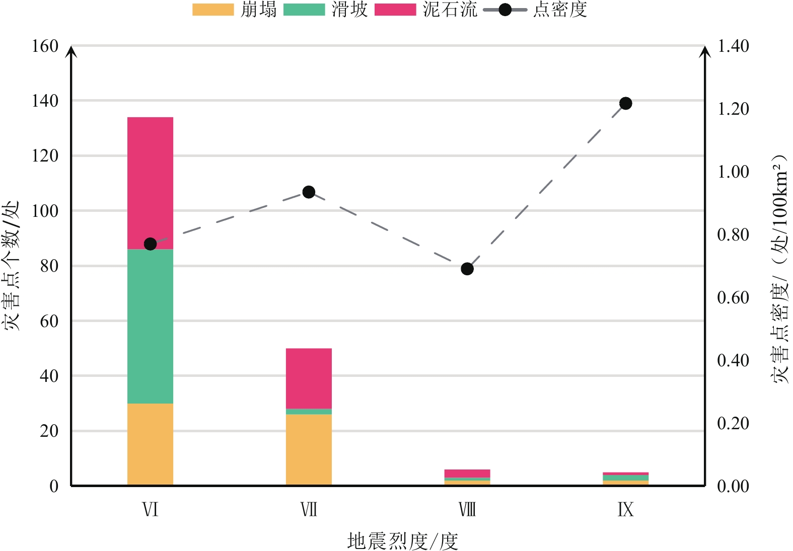
根据震后地质灾害应急排查结果,截至2025年1月15日,此次地震引发91处新增地质灾害点,并导致107处已有地质灾害点发生不同程度变形(图5)。在震后新增的91处地质灾害点中,滑坡34处、崩塌25处,潜在泥石流29处,地裂缝3处,轻微变化的隐患点大多集中在Ⅶ度区和Ⅵ度区,在定日县和拉孜县沿河流呈条带状分布。受地震影响的地质灾害点分布密度与地震烈度呈正相关关系(图6)。
![]() 图 6 震后地质灾害点与地震烈度统计图Figure 6. Statistical diagram of geological damage points and seismic intensities after the earthquake
图 6 震后地质灾害点与地震烈度统计图Figure 6. Statistical diagram of geological damage points and seismic intensities after the earthquake2.3 震区地质灾害形成机制分析
2.3.1 震源机制
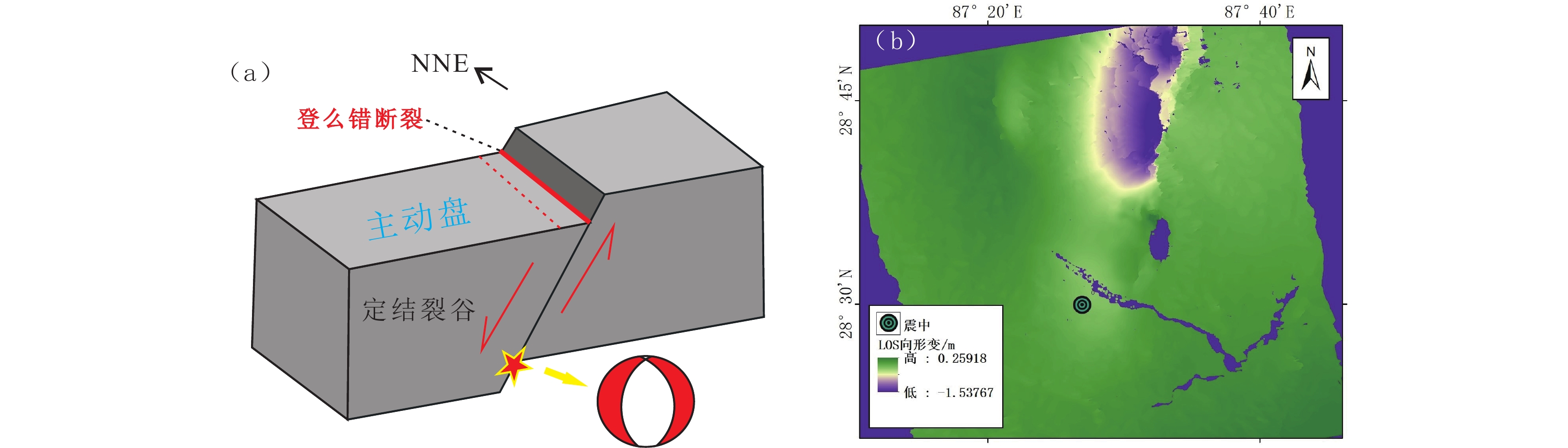
1月7日发生在西藏定日县的Ms6.8级地震发生在青藏高原南部,位于喜马拉雅逆冲断裂系北侧,属喜马拉雅地块内部地震,距南侧藏南拆离断层约15 km。本次地震震源机制解显示为近乎垂直于喜马拉雅逆冲断层系的正断型地震,指示为北北西—南南东向挤压、北东东—南西西向拉张的走滑型应力结构,利用现今GPS速度场模拟获得喜马拉雅地块内部的构造力学环境为南北向挤压为主(Wang and Barbot,2023)。因此,定日Ms6.8级地震与印度板块向欧亚板块汇聚及其造成的喜马拉雅块体内部东西向伸展有关。本次发震断裂登么错断裂走向为NNE,倾向W,断层上盘(西盘)为主动盘(图7a)。
![]() 图 7 定日Ms6.8级地震震源机制(a)及定日县地震区形变分布图(b)Figure 7. Seismogenic fault model diagram of Dingri Ms6.8 earthquake (a) and deformation distribution map of earthquake area in Dingri County (b)
图 7 定日Ms6.8级地震震源机制(a)及定日县地震区形变分布图(b)Figure 7. Seismogenic fault model diagram of Dingri Ms6.8 earthquake (a) and deformation distribution map of earthquake area in Dingri County (b)本次定日县地震导致严重的地表形变,而地表形变在登么错正断层上、下盘呈现出显著的差异(李雨森等,2025)。因登么错断裂上盘(西盘)为主动盘,地表形变主要集中于西盘,为显著的下错变形,最大地表位错达1.5 m。同时受西盘弧形拆离系断裂影响,形变区呈人耳状形态,而在登么错下盘(东盘),地表形变有限,具体见图7b。
2.3.2 震区地质灾害发育特征
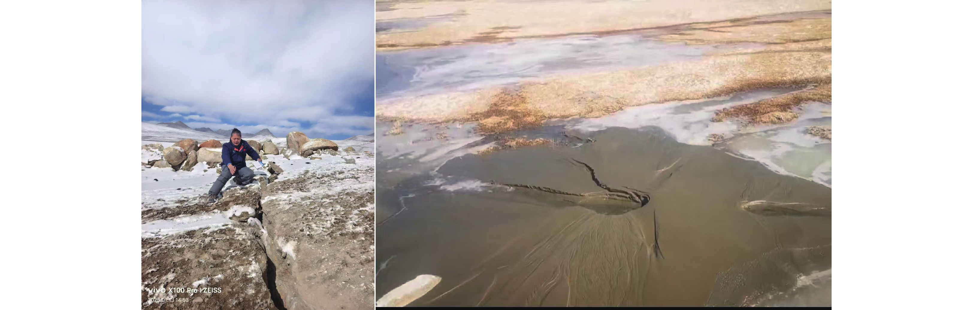
截至2025年1月15日,根据西藏自治区自然资源系统组织完成的震区地质灾害应急排查数据,震区目前已查明的地质灾害点总计959处,其中滑坡138处,泥石流663处,崩塌155处,地裂缝3处。结合震前、震后地质灾害的入库和排查成果,将各类型地质灾害点分成所有点、地震诱发新增点、地震诱发变化点三类数据。调查发现,此次地震还在震中区附近形成长20 km的地表破裂带,最大宽度约0.3 m,并在朋曲河谷内形成了大量砂土液化现象(图8)。为进一步查明区域地质条件对震区地质灾害的控灾机制,论文对构造与岩性、断层、地形等因素与地质灾害的关系进行了研究。
![]() 图 8 定日县地震区地表破裂与砂土液化特征Figure 8. Characteristics of surface rupture and sand liquefaction in earthquake area of Dingri County
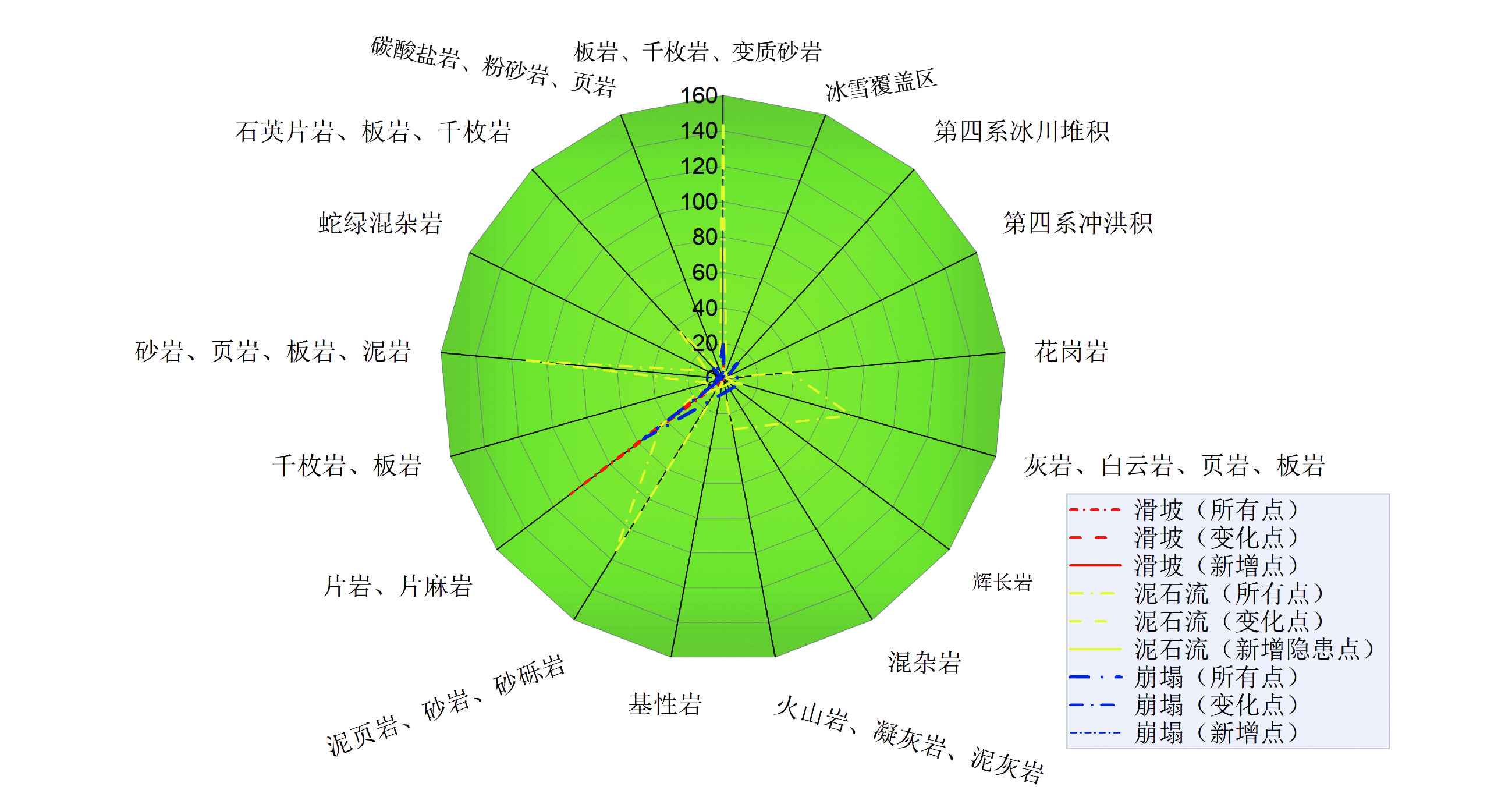
图 8 定日县地震区地表破裂与砂土液化特征Figure 8. Characteristics of surface rupture and sand liquefaction in earthquake area of Dingri County(1)区域构造与岩性控制。本次定日县地震区地质灾害主要集中于特提斯喜马拉雅地块区和雅鲁藏布江缝合带。在特提斯喜马拉雅地块区,因海陆转换和板块碰撞阶段诱发的强挤压变形,地层岩性极为破碎,且多种岩性混杂交织出露(曾庆高等,2020),岩性特征呈现强变形和复杂结构特征,加剧了地质灾害的发育。雅鲁藏布江缝合带多出露蛇绿岩、混杂岩等强蚀变和破碎结构的软弱岩体,一定程度上控制了地质灾害点的集中发育(张永双等,2024)。同时,缝合带内分布有弧前盆地,该区域多发育因构造和造山阶段残留的弧前松散碎屑堆积(潘桂棠等,2019;葛肖虹等,2014),对泥石流的发育作用尤为显著。统计显示:①仅在雅鲁藏布江缝合带,所有复核灾害类型中,灾害点数量高达387处,占比约40%,因地震新增和变化的地质灾害点39处,占比约20%,缝合带发育地质灾害优势显著;②定日县地震区地质灾害点发育的优势岩性主要包括板岩、千枚岩、变质砂岩、砂岩、页岩、片岩、片麻岩、灰岩等,其中新增和有变化地质灾害点多发育于片岩、片麻岩、泥页岩、砂岩、砂砾岩、板岩、千枚岩、变质砂岩、蛇绿混杂岩、第四系冰川堆积区(图9)。
![]() 图 9 定日县地震区各岩性区灾害点分布数量(单位:处)Figure 9. The number of disaster sites distributed in each lithologic area of Dingri County earthquake zone
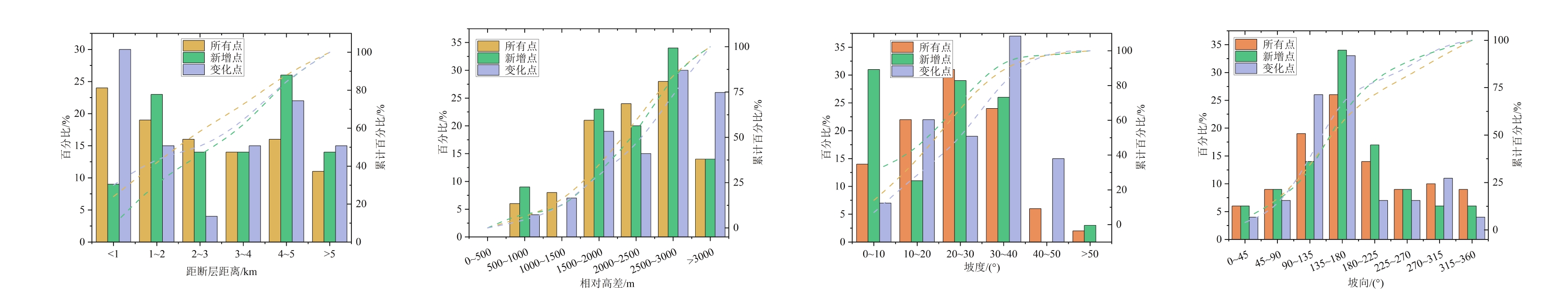
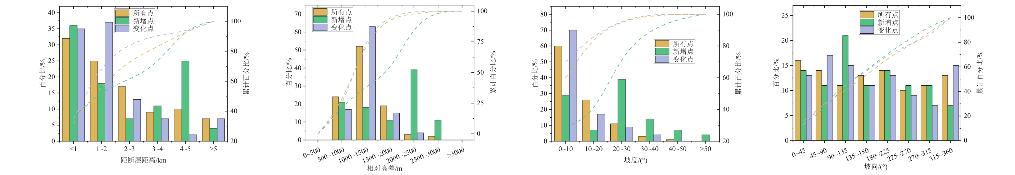
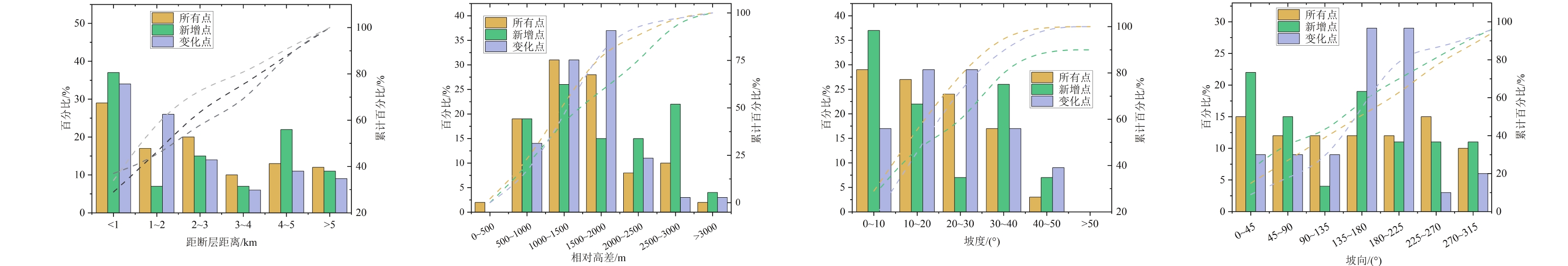
图 9 定日县地震区各岩性区灾害点分布数量(单位:处)Figure 9. The number of disaster sites distributed in each lithologic area of Dingri County earthquake zone(2)活动断裂控制。定日县地震位于登么错拆离断裂区,地震导致严重的地表形变和开裂,如图8所示。定日县地震区周边断层分布密集,断层性质丰富。受印度板块和欧亚板块NS向的强烈挤压,青藏高原发生隆升和快速侧向伸展,在高温高压的中下地壳岩石作塑性形变,但在弹性的上地壳中在垂直于NS挤压方向上形成EW向水平拉张,形成NS向脆性正断层(嵇少丞等,2008;Molnar and Tapponnier,1978; Tapponnier et al.,1981; 韩同林等,1987; 吴中海等,2007)。NS向脆性正断层区多形成裂谷带,这些裂谷区塑造了陡峻的地形,同时伴有断层的分布。与此同时,在水平空间上,因板块NS向的持续挤压,多条EW向的断裂密集分布。因此,在定日县地震区,南北向拆离断裂与东西向逆冲断交汇分布,断层密度高。地震区地质灾害点具有显著的沿断裂发育和集中的趋势(图10c)。此次统计的959余处地质灾害点,滑坡、泥石流、崩塌灾害分别有24%、32%、29%分布于距离断层1 km范围内,距离断层5 km范围内的占比分别高达89%、93%、88%(图11a,图12a,图13a),其中因地震导致的新增点和变化点中,几乎所有类型的地质灾害点发育于断层1 km和5 km范围内的占比分别约占30%和90%。
![]() 图 10 断层、地形等对定日县地震诱发地质灾害点的控制Figure 10. The contributions of faults and topographies to earthquake-induced geological disaster sites in Dingri County
图 10 断层、地形等对定日县地震诱发地质灾害点的控制Figure 10. The contributions of faults and topographies to earthquake-induced geological disaster sites in Dingri County![]() 图 11 滑坡灾害分布与断层距、相对高差、坡度、坡向的关系Figure 11. The relationship between landslide hazard distribution and fault distance, relative elevation difference, slope, and slope direction
图 11 滑坡灾害分布与断层距、相对高差、坡度、坡向的关系Figure 11. The relationship between landslide hazard distribution and fault distance, relative elevation difference, slope, and slope direction![]() 图 12 泥石流灾害分布与断层距、相对高差、坡度、坡向的关系Figure 12. The relationship between debris flow hazard distribution and fault distance, relative elevation difference, slope, and slope direction
图 12 泥石流灾害分布与断层距、相对高差、坡度、坡向的关系Figure 12. The relationship between debris flow hazard distribution and fault distance, relative elevation difference, slope, and slope direction![]() 图 13 崩塌灾害分布与断层距、相对高差、坡度、坡向的关系Figure 13. The relationship between collapse hazard distribution and fault distance, relative elevation difference, slope, and slope direction
图 13 崩塌灾害分布与断层距、相对高差、坡度、坡向的关系Figure 13. The relationship between collapse hazard distribution and fault distance, relative elevation difference, slope, and slope direction(3)地形地貌控制。本次地震区地形条件显著控制了地质灾害的分布。相对高差、坡度和坡向对地质灾害影响显著,尤其是滑坡和崩塌灾害,需要较高的势能和动能条件(图10d-f)。统计发现,滑坡灾害多发育在相对高差为
1500 ~3000 m的范围内,占比达73%(图11b),泥石流多发育于相对高差为500~2000 m的范围内,占比达85%(图12b),崩塌多发育于相对高差为500~2000 m的范围内,占比达78%(图13b),三类灾害新增点和变化点的高程分布基本与所有点一致。滑坡灾害点多发育于坡度为10°~40°的范围内,占比达77%(图11c),泥石流灾害点多发育于坡度为<20°的范围内,占比达86%(图12c),崩塌灾害点在坡度为<40°的范围内均比较发育,占比达97%(图13c)。滑坡灾害其坡向多集中于SEE(90°~135°)、SSE(135°~180°)、SSW(180°~225°)三个方向,占比达59%(图11d),这可能与滑坡灾害多分布于震中南侧的峡谷区有关,即地震诱发滑坡产生了背坡向放大效应。泥石流和崩塌受坡向影响较小(图12d,图13d)。3. 防灾减灾建议
西藏自治区定日县6.8级地震目前已完成首轮地震地质灾害应急排查,下一步将转入地震地质灾害常规排查阶段,并同步启动地震地质灾害防治规划。为准确把握此次地震的影响特征,准确掌握震区地质灾害发展趋势,有针对性地编制科学的地质灾害防治规划方案,基于对定日县6.8级地震地质灾害特征及规律研究,提出下一步震区地质灾害详细调查需关注高位震裂山体、冰湖坝体与后缘冰川、砂土液化调查评价等建议。
(1)高度关注高位震裂山体调查评价,加强新技术方法的应用
根据对典型地区震前和震后高精度遥感影响对比解译,此次地震虽然未造成较为明显的同震滑坡、崩塌等地质灾害,但根据InSAR揭示的区域地表形变场特征分析,震区山体上部具有较为明显的形变过程。因此,震区内高位山体在此次地震中被震裂的分布区域、震裂程度及稳定性调查评价是下一步需要重点关注的内容。鉴于此次震区平均海拔较高,且多数区域为无人区,传统的地表调查难度相对较大,但由于震区地表植被覆盖较差,可采用高精度光学遥感影像解译、InSAR形变监测、无人机三维倾斜摄影及贴近摄影等新技术方法,有针对性地对山体的震裂特征进行精准识别,对高位震裂山体的稳定性进行评价,研判其失稳后可能形成的高速远程地质灾害风险,精准划定潜在危险区范围,为地质灾害风险防控提供科学依据。
(2)重点关注冰湖坝体与后缘冰川稳定性评价,加强地质灾害链风险研判
西藏自治区内的冰湖和冰川多分布在海拔
4000 m以上的区域,受地形高度对震波的放大效应影响,高海拔冰川和冰湖分布区的地震动峰值加速度会显著增大,对冰湖坝体和冰川自身结构造成影响,失稳风险进一步增加。因此,需要对此次地震影响范围内的冰湖坝体及冰川稳定性开展调查评估,充分利用高精度遥感手段查明冰川表面冰裂缝发育规律和冰湖坝体形变特征,对比震前震后冰裂缝和冰湖坝体的变化差异,评价冰川和冰湖坝体稳定性,研判冰川失稳进入冰湖可能导致的冰湖溃决风险,评价冰湖坝体受地震影响下的稳定性及发展趋势,圈定冰湖溃坝灾害链的影响区范围,为震区地质灾害防灾减灾规划提供参考。(3)重点关注砂土液化特征调查评价
此次地震的震中位于朋曲河流域内,震中附近的河谷中冲洪积物、风积沙、湖相沉积物等多成因土体混杂堆积,结构多为粉土、粉砂、细砂、中砂等易液化地层,在地震作用下易发生砂土液化,在此次地震后的调查中在朋曲河谷内发现了多处较为典型的同震砂土液化现象,导致地表产生形变破坏,虽然未发现因砂土液化导致的房屋或建筑受损现象,但对这类特殊成因灾害需要加强调查评价,要进一步查明朋曲河谷内砂土液化区的空间分布特征、液化区土体结构与地下水和地震烈度的关系,总结地震工况下砂土液化机理及破坏模式,为今后同类地质结构地区砂土液化灾害防范提供科学参考,也为未来区朋曲河谷及周边类似区域城镇、工程规划建设选址防灾减灾提供依据。
(4)需重点关注地震地表破裂带调查评价
根据野外调查,此次地震在地表形成了十余千米的地表变形带和数百米的地表破裂带,最大破裂带下错高度可超过3 m,且局部破裂带区域存在蠕动变形现象,特别是在斜坡地带易演化成次生地质灾害,对建筑及基础设施造成破坏。今后需关注并加大震区大比例尺基础地质调查力度,特别要查明区域断层的活动性、层空间展布特征,精准划定潜在地表破裂带范围,研判地表破裂可能的致灾模式及风险,提出合理的避让距离,结合国土空间规划提出科学的防灾减灾建议。
4. 结论
(1)受定日县地震影响的5个主要县震前境内在册地质灾害隐患点共868处,灾害规模以小型和中型为主,其中小型555处、中型252处、大型60处、特大型1处。
(2)此次地震震区新增地质灾害点91处,其中滑坡34处、崩塌25处、泥石流29处、地裂缝3处。同时,受地震影响发生变形的灾害点107处。
(3)定日县地震发生于拉萨地块和喜马拉雅地块的结合部位以南仅约80 km,NS向断裂、裂谷及EW向断裂密集发育,区域岩性、断裂和地形显著控制着震区地质灾害的发育分布,如区内的雅鲁藏布江缝合带软弱岩体内地质灾害发育数量占比高达40%。
(4)相比其他地区同震级地震而言,定日县地震诱发的同震地质灾害数量相对较少,灾害规模也较小,但受地形对地震波的放大效应影响,发育在高山或极高山地区的高位山体、冰川、冰湖等可能会受到不同程度的影响,需要高度关注对这类可能诱发地质灾害或潜在灾害链的易灾地质体调查评价。
(5)定日县地震区灾后重建中,特别是重要城镇或工程建设选址时,要充分考虑强震工况下河谷区深厚覆盖砂土层液化和潜在地表破裂带致灾风险,并开展专项评估。
致谢:本文在野外数据获取方面得到了日喀则市自然资源局、西藏自治区地质矿产勘查开发局、四川省地质矿产勘查开发局、四川省地质调查研究院、四川省自然资源投资集团等单位技术人员的大力支持,在此一并表示感谢!
1 *数据资料请联系编辑部或登录期刊官网https://www.cjyttsdz.com.cn/获取。 -
![]()
图 1 a. 中亚造山带构造格架图(据杨高学等,2023;Jahn et al.,2000);b. 西准噶尔地区岛弧环境示意图(据Chen et al.,2015);c. 西准噶尔地质简图(据杨高学等,2023;Ren et al.,2017);d. 沙尔布尔提山西南侧地层划分图;e. 芒克鲁Ⅱ剖面地层柱状图 (图例参考后文)
Figure 1. a. Structural framework map of the CAOB (modified from Yang et al., 2023; Jahn et al., 2000); b. Island arc environmental map of western Junggar (modified from Chen et al., 2015); c. Geological map of western Junggar (modified from Yang et al., 2023; Ren et al., 2017); d. Gological map of Shaerbuerti Mountain's southwest side; e. Brief lithological column of the Mangkelu Ⅱ section
![]()
图 3 岩相1、岩相2、岩相3露头特征和典型沉积构造
a. 岩相1~3详细岩性柱状图;b. 岩相1粗粒浊积岩(剖面-160~-150 m处);c-g. 岩相2堆叠的板状砂岩(复理石建造,剖面6~16 m处);d. 植物化石(剖面5 m处);e. 单层砂岩中的正粒序和牵引构造(层理)(剖面15 m处);f. 生物碎屑砂岩(6-1层);g. 6-2层砂岩中的泥岩碎屑(剖面11 m处);h. 岩相3厚层无结构粉砂岩(剖面-80 m处)
Figure 3. Outcrop features and typical sedimentary structures for lithofacies 1, 2, and 3
![]()
图 6 砂岩薄片镜下特征
a. 长石岩屑杂砂岩(KM-6-1-2,剖面4 m处);b. 长石岩屑杂砂岩(KM-6-2-1,剖面13 m处);c. 黑云母岩屑砂岩(MK-9,剖面90 m处);d. 海绿石长石岩屑杂砂岩(KM-10-2,剖面96 m处);e. 钙质粉砂岩(MK-13-2,剖面200 m处);f. 长石岩屑杂砂岩(KM-16-2,剖面250 m处)。Qm—单晶石英;F—长石;L—岩屑;Cm—生物碎屑;Gla—海绿石;Cht—燧石
Figure 6. Sandstone thin-section features under the polarizing microscope
![]()
图 4 岩相4露头特征和典型沉积构造
a. 岩相4详细岩性柱状图;b. 岩相4中含大量植物碎片的白色粗砂岩层(剖面90 m处);c. 岩相4中极薄层的陆地植物碎片层,红色框内为其层面(剖面90 m处);d. 岩相4双向粒序层(剖面125 m处);e. 岩相4双向粒序层(剖面110 m处)
Figure 4. Outcrop features and typical sedimentary structures for lithofacies 4
![]()
图 5 岩相5、岩相6露头特征和典型沉积构造
a. 岩相5、6详细岩性柱状图;b-d. 岩相5:含生物碎屑的钙质粉砂岩,其中夹少量钙质生物碎屑灰岩条带或者透镜体,化石保存多为碎片(12层,160 m处);c-e. 岩相5:生物碎屑的钙质粉砂岩,注意原位保存的苔藓虫和珊瑚(13层,230 m处);f. 岩相6:交错层理发育的中—粗粒砂屑灰岩(16层—17层,260 m处);g. 砂屑灰岩交错层理发育(17层);h. 鱼骨(羽)状交错层理;i. 槽状交错层理
Figure 5. Outcrop features and typical sedimentary structures for lithofacies 5 and 6
![]()
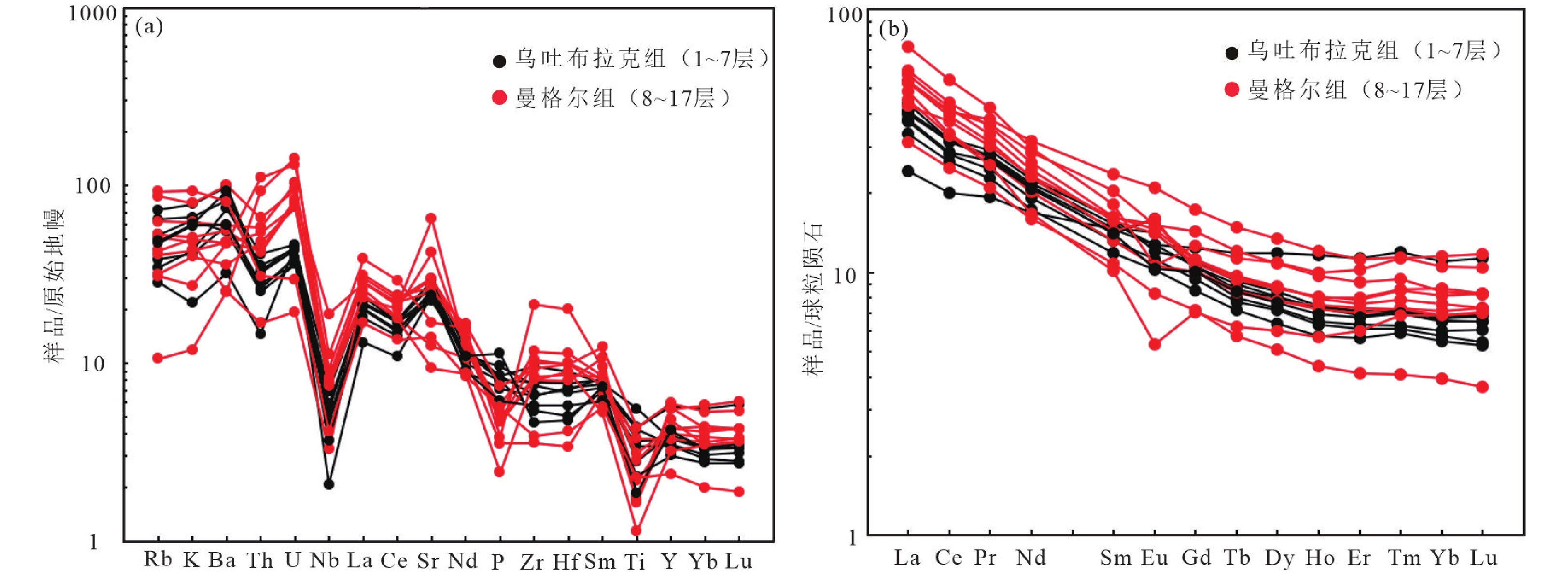
图 7 a. 芒克鲁Ⅱ剖面砂岩微量元素原始地幔标准化蛛网图(数据来自Sun and McDonough,1989);b. 稀土元素球粒陨石标准化配分型式图(数据来自Taylor and McLennan,1985)
Figure 7. a. Primitive mantle-normalized spider diagram (data from Sun and McDonough, 1989); b. Chondrite-normalized REE patterns of the Mangkelu Ⅱ section (data from Taylor and McLennan, 1985)
![]()
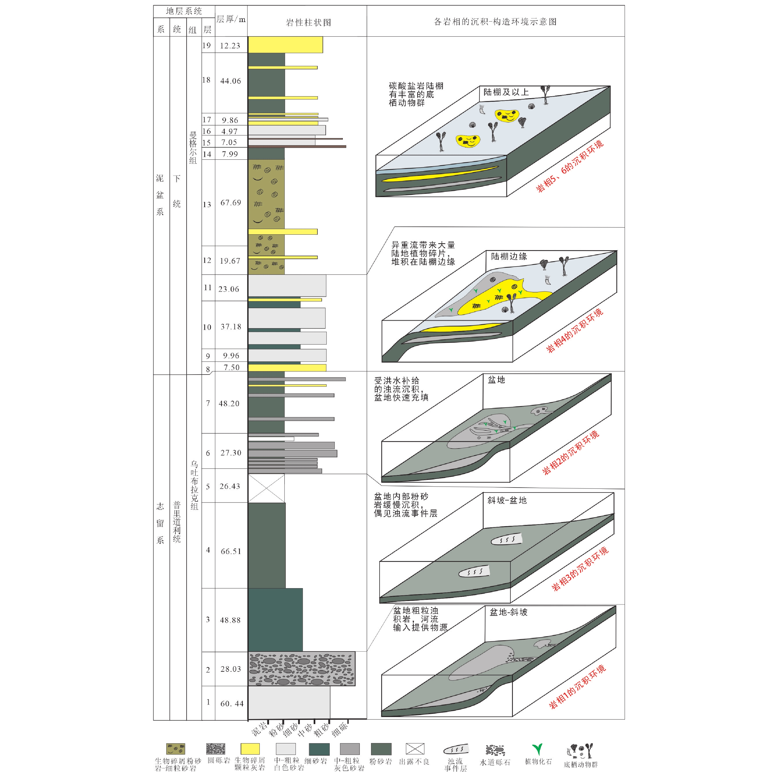
图 8 芒克鲁Ⅱ剖面盆地充填序列中各岩相的沉积–构造环境示意图
Figure 8. Sedimentary evolution of basin filling sequence at the Mangkelu Ⅱ section
![]()
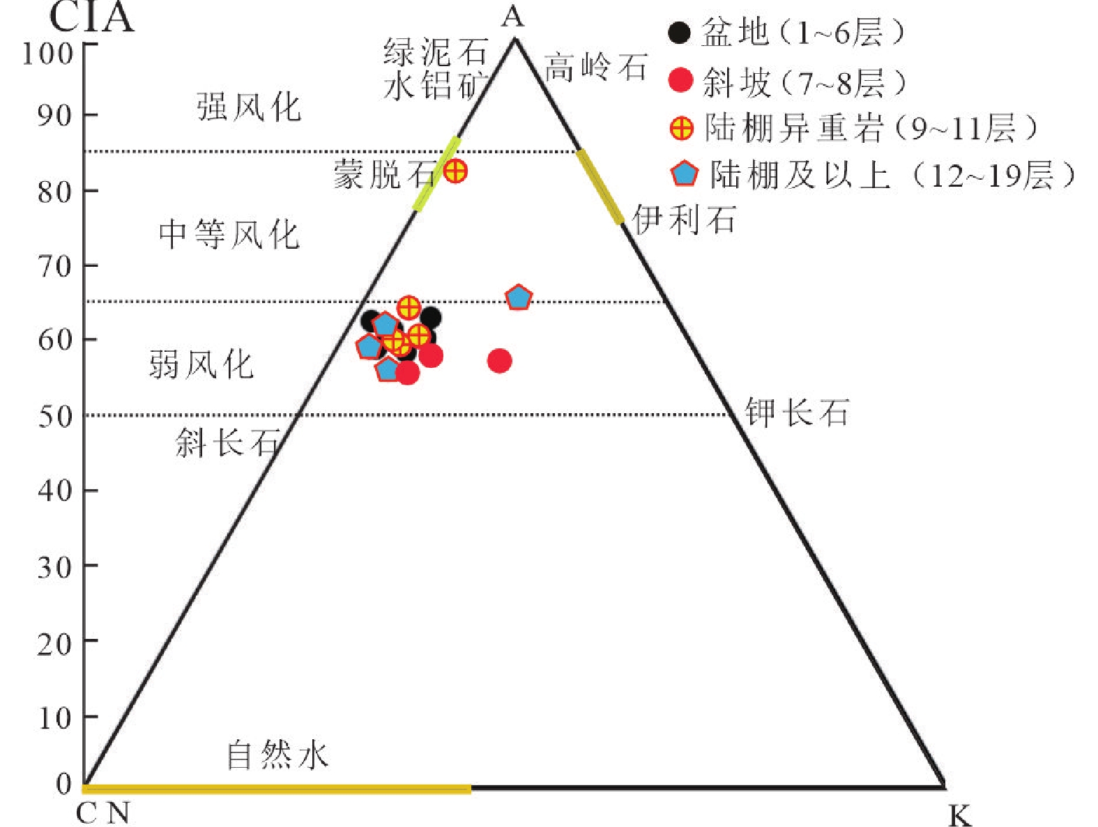
图 9 芒克鲁Ⅱ剖面砂岩A–CN–K(Al2O3–CaO*+Na2O–K2O)图解
Figure 9. A–CN–K (Al2O3–CaO*+Na2O–K2O) diagram for sandstones at the Mangkelu Ⅱ section
![]()
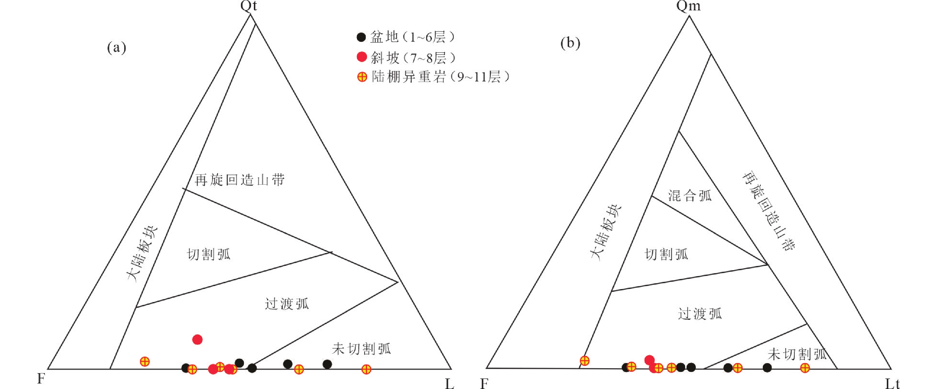
图 10 砂岩碎屑组分与物源类型判别图解(底图据Dickinson,1979)
稳定石英颗粒总量:Qt=Qm+Qp;不稳定岩屑:L=Lv+Ls;岩屑总量:Lt=L+Qp;长石:F
Figure 10. Sandstone detrital composition and provenance analysis diagram (modified from Dickinson, 1979)
![]()
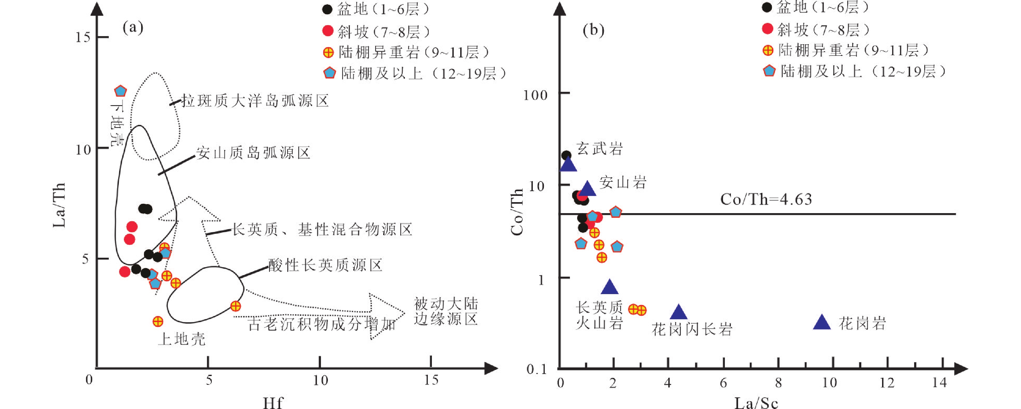
图 11 芒克鲁Ⅱ剖面砂岩物源属性判别图解
a. La/Th–Hf图解(Floyd and Leveridge,1987);b. Co/Th–La/Sc图解(Gu et al.,2002)
Figure 11. Provenance attribute discrimination diagrams for sandstones from the Mangkelu Ⅱ section
![]()
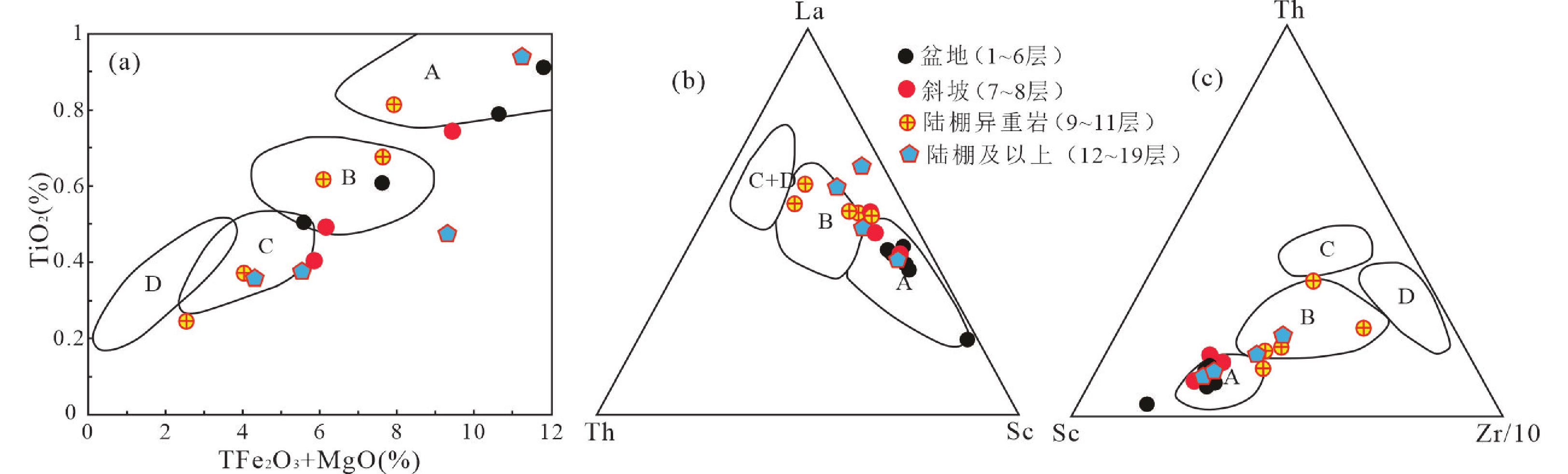
图 12 砂岩主、微量元素构造判别图解
a. TiO2–TFe2O3+MgO 图解(Bhatia,1983);b. La–Th–Sc图解(Bhatia,1985);c. Th–Sc–Zr/10图解(Bhatia,1985);A—大洋岛弧;B—大陆岛弧;C—活动大陆边缘;D—被动大陆边缘
Figure 12. Tectonic discrimination diagrams of the major and trace elements for sandstones from the Mangkelu Ⅱ section
![]()
图 13 a. 芒克鲁Ⅱ剖面沉积模式图;b. 不同沉积环境下的岩相类型图;c-d. 准噶尔谢米斯台山–沙尔布尔提山岛弧碰撞构造沉积演化图(据Choulet et al.,2012; 纵瑞文,2016修改)
c. 表示剖面下部岩相1~4;d. 表示剖面上部早泥盆世曼格尔组(岩相5~6)及上覆地层和和布克赛尔组碳酸盐岩沉积
Figure 13. a. Sedimentary model of the Mangkelu Ⅱ section; b. Lithic facies type maps in different sedimentary environments; c-d. Tectonic-sedimentary evolution of the Xiemisitai-Shaerbuerti arc collision (modified from Choulet et al., 2012; Zong, 2016)
表 1 砂岩构造背景的稀土元素判别参数(Bhatia,1985)与本区砂岩的对比
Table 1 Comparison of sandstone discriminant parameters and tectonic settings of REEs (after Bhatia, 1985)
构造背景 源区类型 La/×10-6 Ce/×10-6 ∑REE/×10-6 LREEs/HREEs (La/Yb)N Eu/Eu* 大洋岛弧 未切割岩浆弧 8.00±1.70 19.00±3.70 58.00±10.00 3.80±0.90 2.80±0.90 1.04±0.11 大陆岛弧 切割岩浆弧 27.00±4.54 59.00±8.20 146.00±20.00 7.70±1.70 7.50±2.50 0.79±0.13 活动大陆边缘 隆升基底隆起 37.00 79.00 186.00 9.10 8.50 0.60 被动大陆边缘 克拉通内高地 39.00 85.00 210.00 8.50 10.80 0.56 盆地相(1~6层均值) 13.69 27.64 75.33 5.65 5.67 1.06 斜坡相(7~8层均值) 13.10 26.05 68.85 6.49 6.80 0.94 陆棚异重岩相(9~11层均值) 20.95 40.76 100.13 7.20 6.80 0.96 陆棚及以上(12~19层均值) 18.12 36.52 97.47 5.92 6.01 0.99  下载: 导出CSV
-
[1] 包万铖,夏国清,路畅,等,2023. 西藏伦坡拉盆地牛堡组二段晚始新世−早渐新世地球化学特征与古气候意义[J]. 沉积与特提斯地质,43(3):580 − 591. Bao W C,Xia G Q,Lu C,et al.,2023. Late Eocene to early Oligocene geochemical characteristics and paleoclimatic significance of the second member of Niubao Formation in the Lunpola Basin,Tibet[J]. Sedimentary Geology and Tethyan Geology,43(3):580 − 591 (in Chinese with English abstract).
[2] Bhatia M R,1983. Plate tectonics and geochemical composition of sandstones[J]. The Journal of Geology,91(6):611 − 627.
[3] Bhatia M R,1985. Rare earth element geochemistry of Australian Paleozoic graywackes and mudrocks:Provenance and tectonic control[J]. Sedimentary Geology,45:97 − 113. DOI: 10.1016/0037-0738(85)90025-9
[4] Bhatia M R,Crook K,1986. Trace element characteristics of graywackes and tectonic setting discrimination of sedimentary basins[J]. Contributions to Mineralogy & Petrology,92:181 − 193.
[5] Cai C Y,Dou Y W,Edwards D,1993. New observations on a Pridoli plant assemblage from north Xinjiang,northwest China,with comments on its evolutionary and palaeogeographical significance[J]. Geological Magazine,130(2):155 − 170.
[6] Chen J F,Han B F,Zhang L,et al.,2015. Middle Paleozoic initial amalgamation and crustal growth in the West Junggar (NW China): Constraints from geochronology,geochemistry and Sr-Nd-Hf-Os isotopes of calc-alkaline and alkaline intrusions in the Xiemisitai-Saier Mountains[J]. Journal of Asian Earth Sciences,113:90−109.
[7] Chen Wen,Windley,et al.,2017. Late Silurian-early Devonian adakitic granodiorite,A-type and I-type granites in NW Junggar,NW China:Partial melting of mafic lower crust and implications for slab roll-back[J]. Gondwana Research,43:55 − 73.
[8] Choulet F,Faure M,Cluzel D,et al.,2013. Architecture and evolution of accretionary orogens in the Altaids Collage:The early Paleozoic West Junggar (NW China)[J]. American Journal of Science,312:1098 − 1145.
[9] Cox R,Lowe D R,Cullers R L,1995. The influence of sediment recycling and basement composition on evolution of mudrock chemistry in the southwestern United States[J]. Geochimica et Cosmochimica Acta,59:2919 − 2940. DOI: 10.1016/0016-7037(95)00185-9
[10] Dickinson W R,1979. Plate tectonics and sandstone compositions[J]. AAPG Bulletin,63:2164 − 2182.
[11] Dickinson W R,Valloni R,1980. Plate settings and provenance of sands in modern ocean basins[J]. Geology,8(2):82 − 86.
[12] Dickinson W R,Beard L S,Brakenridge G R,et al.,1983. Provenance of north American Phanerozoic sandstones in relation to tectonic setting[J]. Geological Society of America Bulletin,94(2):222 − 235.
[13] Dickinson W R,1985. Interpreting provenance relations from detrital modes of sandstones[J]. Provenance of Arenites,148:333 − 361.
[14] Dickinson W R,1988. Provenance and sediment dispersal in relation to paleotectonics and paleogeography of sedimentary basins[J]. Springer New York:3 – 25.
[15] Dykstra M,Kneller B,2009. Lateral accretion in a deep-marine channel complex:Implications for channellized flow processes in turbidity currents[J]. Sedimentology,56:1411 − 1432. DOI: 10.1111/j.1365-3091.2008.01040.x
[16] Fan R Y,Gong Y M,2016. Ichnological constraints of palaeoenvironmental and palaeoclimatological features of the middle Palaeozoic Palaeo-Asian Ocean,evidence from the western Junggar,NW China[J]. Palaeogeography,Palaeoclimatology,Palaeoecology,459:209 − 228.
[17] Fedo C M,Nesbitt H W,Young G M,1995. Unraveling the effects of potassium metasomatism in sedimentary rocks and paleosols,with implications for paleoweathering conditions and provenance[J]. Geology,23:921 − 924.
[18] Floyd P A,Leveridge B E,1987. Tectonic environment of the Devonian gramscatho basin,south Cornwall:Framework mode and geochemical evidence from turbiditic sandstones[J]. Journal of the Geological Society,144:531 − 542. DOI: 10.1144/gsjgs.144.4.0531
[19] 龚一鸣,纵瑞文,王国灿,等,2013. 西准噶尔古生代地层区划及古地理格局[J]. 地层学杂志,37(4):590 − 592. Gong Y M,Zong R W,Wang G C,et al.,2013. Paleozoic stratigraphic regionalization and paleogeographic pattern in western Junggar,Northwestern China[J]. Journal of Stratigraphy,37(4):590 − 592 (in Chinese with English abstract).
[20] Gu X X,Liu J M,Zheng M H,et al.,2002. Provenance and tectonic setting of the Proterozoic turbidites in Hunan,South China:Geochemical evidence[J]. Journal of Sedimentary Research,72:393 − 407. DOI: 10.1306/081601720393
[21] Hein F J,Walker R G,1982. The Cambro‐Ordovician Cap Enragé Formation,Queébec,Canada: Conglomeratic deposits of a braided submarine channel with terraces[J]. Sedimentology,29(3):309 − 329. DOI: 10.1111/j.1365-3091.1982.tb01798.x
[22] Jahn B M,Wu F Y,Chen B,2000. Granitoids of the Central Asian Orogenic Belt and continental growth in the Phanerozoic[C]//The Fourth Hutton Symposium on the Origin of Granites and Related Rocks. Geological Society of America:0. 10.1130/0-8137-2350-7.181.
[23] Johnson K S,et al.,2001. A decadal record of underflows from a coastal river into the deep sea[J]. Geology,29:1019 − 1022.
[24] Liang H,Chen J F,Ma X,et al.,2020. Detrital zircon U‐Pb geochronology and provenance of the Hebukesaier Formation in the Shaerbuerti Mountains,northern West Junggar:Implication for devonian subduction of the Junggar–Balkhash Ocean[J]. Acta Geologica Sinica - English Edition,94:1410 − 1427. DOI: 10.1111/1755-6724.14327
[25] 李锦轶,2004. 新疆东部新元古代晚期和古生代构造格局及其演变[J]. 地质论评,50(3):19. Li J Y,2004. Late Neoproterozoic and Paleozoic tectonic framework and evolution of eastern Xinjiang,NW China[J]. Geological Review,50(3):19 (in Chinese with English abstract).
[26] Li P,Kneller B,Thompson P,et al.,2018. Architectural and facies organisation of slope channel fills:Upper Cretaceous Rosario Formation,Baja California,Mexico[J]. Marine and Petroleum Geology,92:632 − 649. DOI: 10.1016/j.marpetgeo.2017.11.026
[27] Liu B,Han B F,Chen J F,et al.,2017. Closure time of the Junggar-Balkhash Ocean:Constraints from late Paleozoic volcano-sedimentary sequences in the Barleik Mountains,West Junggar,NW China[J]. Tectonics,36:2823 − 2845. DOI: 10.1002/2017TC004606
[28] 刘子玉,吕明,卢景美,等,2017. 东非鲁伍马盆地窄陆架背景下的深水沉积体系[J]. 海相油气地质,22(4):27 −34. Liu Z Y,Lü M,Lu J M,et al.,2017. Deepwater depositional system in the background of narrow shelf in the Ruvuma Basin,eastern Africa[J]. Marine Origin Petroleum Geology,22(4):27 −34 (in Chinese with English abstract).
[29] 李忠,2013. 中国的盆地动力学——21世纪开初十年的主要研究进展及前沿[J]. 矿物岩石地球化学通报,32(3):290 − 300. Li Z,2013. Sedimentary basin geodynamics in China:Advances and frontiers during the first decade of the 21th century[J]. Bulletin of Mineralogy,Petrology and Geochemistry,32(3):290 − 300 (in Chinese with English abstract).
[30] 马安林,胡修棉,2021. 沉积记录约束班公湖−怒江缝合带东巧蛇绿岩的仰冲过程[J]. 沉积与特提斯地质,41(2):163 − 175. Ma A L,Hu X M,2021. Constraining the obduction process of the Dongqiao ophiolite in the Bangongco-Nujiang suture zone by the sedimentary record[J]. Sedimentary Geology and Tethyan Geology,41(2):163 − 175 (in Chinese with English abstract).
[31] Ma J,Yin J,Liu Y,et al.,2023. The latest encrinurid trilobites from the Lower Devonian of Xinjiang,Northwest China[J]. Geological Magazine,160:1578 − 1585.
[32] Martinsen O J,Smme T O,Helland‐Hansen W,et al.,2009. Relationships between morphological and sedimentological parameters in source‐to‐sink systems: a basis for predicting semi‐quantitative characteristics in subsurface systems[J]. Basin Research,21(4):361 − 387. DOI: 10.1111/j.1365-2117.2009.00397.x
[33] McLennan S M,Hemming S R,Mcdaniel D K,et al.,1993. Geochemical approaches to sedimentation,provenance,and tectonics[C]//Processes Controlling the Composition of Clastic Sediments. Geological Society of America:0. 10.1130/SPE284-p21.
[34] M L Irwin, 1980. 陆表海清水沉积作用的一般原理[M]. 冯增昭, 译. 石油地质学译文集( 第四集): 碳酸盐岩沉积环境. 北京: 科学出版社: 10 − 24. M L Irwin,1980. General principles of clear water in eperic sea[M]//M M Aslani,et al.,translated by Feng Zengzhao. Carbonate Sedimentary Environments,Series 4 of Collections of Translated Papers on Petroleum Geology. Beijing:Science Press:10 − 24.
[35] 牟传龙,2022. 关于相的命名及其分类的建议[J]. 沉积与特提斯地质,42(3):331 − 339. Mou C L,2022. Suggested naming and classification of the word facies[J]. Sedimentary Geology and Tethyan Geology,42(3):331 − 339 (in Chinese with English abstract).
[36] 牟传龙, 2022. 关于相的命名及其分类的建议[J]. 沉积与特提斯地质, 42(3): 331 − 339. Mulder T,Syvitski J P M,Migeon S,et al.,2003. Marine hyperpycnal flows:Initiation,behavior and related deposits. A review[J]. Marine and Petroleum Geology,20:861 − 882.
[37] Mulder T,Alexander J,2001. The physical character of subaqueous sedimentary density flows and their deposits[J]. Sedimentology,48(2):269 − 299.
[38] Mutti E,Normark W R,1987. Comparing examples of modern and ancient turbidite systems:Problems and concepts[J]. Marine Clastic Sedimentology:1 − 38.
[39] Nesbitt H W,Young G M,1982. Early Proterozoic climates and plate motions inferred from major element chemistry of lutites[J]. Nature,299:715 − 717.
[40] Ni Y,Lenz A,Chen X,1998. Pridoli graptolites from northern Xinjiang,Northwest China[J]. Canadian Journal of Earth Sciences,35:1123 − 1133. DOI: 10.1038/299715a0
[41] 欧阳京,汪双双,于漫,等,2010. 岛弧环境中不同成因的火成岩组合及其地质意义[J]. 甘肃地质,19(2):18−26. DOI: 10.1139/e98-059 Ouyang J,Wang S S,Yu M,et al.,2010. Igneous assemblages of different origin in islandarc and their geological significances[J]. Gansu Geology,19(2):18 − 26 (in Chinese with English abstract). DOI: 10.1139/e98-059
[42] 欧阳京, 汪双双, 于漫, 等, 2010. 岛弧环境中不同成因的火成岩组合及其地质意义[J]. 甘肃地质, 19(2): 18−26. Perfit M R,Gust D A,Bence A E,et al.,1980. Chemical characteristics of island-arc basalts:Implications for mantle sources[J]. Chemical Geology,30:227 − 256.
[43] Ping S,Shen Y,Li X H,et al.,2012. Northwestern Junggar Basin,Xiemisitai Mountains,China:A geochemical and geochronological approach[J]. Lithos,140−141:103 − 118. DOI: 10.1016/0009-2541(80)90107-2
[44] Piret Plink-Björklund,Ron J Steel,2004. Initiation of turbidity currents:Outcrop evidence for Eocene hyperpycnal flow turbidites[J]. Sedimentary Geology,165(1 − 2):29 − 52. DOI: 10.1016/j.lithos.2012.02.004
[45] Ren R,Han B,Xu Z,et al.,2014. When Did the Subduction First Initiate in the Southern Paleo-Asian Ocean:New Constraints from a Cambrian Intra-Oceanic Arc System in West Junggar,NW China[J]. Earth and Planetary Science Letters,388:222 − 236.
[46] Ren R,Han B F,Guan S W,et al.,2017. Linking the southern West Junggar Terrane to the Yili Block:Insights from the oldest accretionary complexes in West Junggar,NW China[J]. Journal of Asian Earth Sciences,159:279 − 293. DOI: 10.1016/j.jpgl.2013.11.055
[47] Roser B P,Korsch R J,1986. Determination of tectonic setting of sandstone-mudstone suites using SiO2 content and K2O/Na2O ratio[J]. Journal of Geology,94:635 − 650.
[48] 阮伟,黄洁,2010. 潮流沙脊和沙波沉积结构特征——以西班牙东北部比利牛斯前陆盆地Roda砂岩组为例[J]. 沉积学报,28:118 − 127. DOI: 10.1086/629071 Ruan W,Huang J,2010. Sedimentary architecture characteristics of tidal bars and dunes:An example from Roda sandstone in Pyrenean foreland basin,NE Spain[J]. Acta Sedimentologica Sinica,28:118 − 127 (in Chinese with English abstract). DOI: 10.1086/629071
[49] 阮伟, 黄洁, 2010. 潮流沙脊和沙波沉积结构特征——以西班牙东北部比利牛斯前陆盆地Roda砂岩组为例[J]. 沉积学报, 28: 118 − 127. Rudnick R,Shan G,2003. Composition of the continental crust [J]. Treatise on Geochemistry,3:1 − 64.
[50] Şengör A M C,Natal'in B A,Burtman V S,1993. Evolution of the altaid tectonic collage and Palaeozoic crustal growth in Eurasia[J]. Nature,364:299 − 307.
[51] Şengör A M C,Natal'in B A,1996. Turkic-Type orogeny and its role in the making of the continental crust[J]. Annual Review of Earth and Planetary Sciences,24:263 − 337. DOI: 10.1038/364299a0
[52] Shen P,Pan H D,Xiao W J,et al.,2014. An Ordovician intra-oceanic subduction system influenced by ridge subduction in the West Junggar,Northwest China[J]. International Geology Review,56:206 − 223. DOI: 10.1146/annurev.earth.24.1.263
[53] Stow D,1985. Fine-grained sediments in deep-water:An overview of processes and facies models[J]. Geo-Marine Letters,5:17 − 23. DOI: 10.1080/00206814.2013.839096
[54] Stow D,Smillie Z,2020. Distinguishing between deep-water sediment facies:Turbidites,contourites and hemipelagites[J]. Geosciences,10:68.
[55] Steel E,Simms A R,Steel R,et al.,2018. Hyperpycnal delivery of sand to the continental shelf:Insights from the Jurassic Lajas Formation,Neuquén Basin,Argentina[J]. Sedimentology,65(6):2149 − 2170. DOI: 10.3390/geosciences10020068
[56] Sun,McDonough,1989. Chemical and isotopic systematics of oceanic basalts:Implications for mantle composition and processes[J]. Geological Society London Special Publications,42(1):313 − 345. DOI: 10.1111/sed.12460
[57] 孙福宁,杨仁超,李冬月,2016. 异重流沉积研究进展[J]. 沉积学报,34(3):452 − 462. Sun F N,Yang R C,Li D Y,2016. Research progresses on hyperpycnal flow deposits[J]. Acta Sedimentologica Sinica,34(3):452 − 462 (in Chinese with English abstract).
[58] 唐华,胡林,魏龙,等,2020. 西藏尼木地区变质火山岩的地球化学特征、锆石U-Pb年龄及其地质意义[J]. 沉积与特提斯地质,40(2):104 − 115. Tang H,Hu L,Wei L,et al.,2020. The geochemistry and zircon U-Pb dating for the metamorphic volcanic rocks in Nimu area,Tibet[J]. Sedimentary Geology and Tethyan Geology,40(2):104 − 115 (in Chinese with English abstract).
[59] 唐华, 胡林, 魏龙, 等, 2020. 西藏尼木地区变质火山岩的地球化学特征、锆石U-Pb年龄及其地质意义[J]. 沉积与特提斯地质, 40(2): 104 − 115. Taylor S R,McLennan S M,1985. The continental crust:Its composition and evolution[J]. The Journal of Geology,94:57 − 72.
[60] Van D,Leake B E,1985. Petrography and geochemistry of feldspathic and mafic sediments of the northeastern Pacific margin[J]. Transactions of the Royal Society of Edinburgh. Earth sciences,76:411 − 449.
[61] Walker R G,1978. Deep-water sandstone facies and ancient submarine fans: Models for exploration for stratigraphic traps[J]. AAPG Bulletin,62:239 − 263.
[62] 王俊,江武龙,余雅兰,等,2023. 华北克拉通南缘中元古界熊耳群大古石组沉积环境——来自地球化学的证据[J/OL]. 沉积学报:1 − 20[2025-02-25]. https://doi.org/10.14027/j.issn.1000-0550.2023. 012. Wang J,Wang W L,Yu Y L,et al.,2023. Depositional environment of the Dagushi Formation,Mesoproterozoic Xiong’er Group,southern North China Block:Evidence from geochemical analysis[J/OL]. Acta Sedimentologica Sinica:1 − 20[2025-02-25]. https://doi.org/10. 14027/j.issn.1000-0550.2023.012 (in Chinese with English abstract).
[63] 王志宏,龚一鸣,纵瑞文,等,2014. 西准噶尔乌兰柯顺地区晚泥盆世朱鲁木特组地层新知[J]. 地层学杂志,38(1):51 − 59. Wang Z H,Gong Y M,Zong R W,et al.,2014. New knowledge about the Late Devonian Zhulumute Formation in the Wulankeshun region,Western Junggar[J]. Journal of Stratigraphy,38(1):51 − 59 (in Chinese with English abstract).
[64] 王志宏,纵瑞文,龚一鸣,等,2015. 晚泥盆世牙形刺及软骨鱼类在西准噶尔塔克台组中的发现及意义[J]. 地球科学,40(3):588 − 596. Wang Z H,Zong R W,Gong Y M,et al.,2015. Late Devonian conodonts and chondrichthyes from Taketai Formation in western Junggar,NW China[J]. Earth Science,40(3):588 − 596 (in Chinese with English abstract).
[65] 卫巍,庞绪勇,王宇,等,2009. 北疆沙尔布尔提山地区早泥盆−早石炭世沉积相、物源演变及其意义[J]. 岩石学报,25(3):689 − 698. Wei W,Pang X Y,Wang Y,et al.,2009. Sediment facies,provenance evolution and their implications of the Lower Devonian to Lower Carboniferous in Shaerbuerti Mountain in North Xinjiang[J]. Acta Petrologica Sinica,25(3) :689 − 698 (in Chinese with English abstract).
[66] 卫巍, 庞绪勇, 王宇, 等, 2009. 北疆沙尔布尔提山地区早泥盆−早石炭世沉积相、物源演变及其意义[J]. 岩石学报, 25(3): 689 − 698. Windley B F,Alexeiev D,Xiao W,et al.,2007. Tectonic models for accretion of the Central Asian Orogenic Belt[J]. Journal of the Geological Society,164:31 − 47.
[67] Windley B,Xiao W,2018. Ridge subduction and slab windows in the Central Asian Orogenic Belt:Tectonic implications for the evolution of an accretionary orogen[J]. Gondwana Research,61:73 − 87. DOI: 10.1144/0016-76492006-022
[68] Xiao W J,Zhang L C,Qin K Z,et al.,2004. Paleozoic accretionary and collisional tectonics of the eastern Tianshan (China):Implications for the continental growth of central Asia[J]. American Journal of Science,304(4):370 − 395
[69] Xiao W J,Kusky T,2009. Geodynamic processes and metallogenesis of the Central Asian and Related Orogenic Belts:Introduction[J]. Gondwana Research,16:167 − 169.
[70] Xiao W,Huang B,Han C,et al.,2010. A review of the western part of the Altaids: A key to understanding the architecture of accretionary orogens[J]. Gondwana Research,18:253 − 273.
[71] Xu Z,Han B F,Ren R,et al.,2013. Palaeozoic multiphase magmatism at Barleik Mountain,southern West Junggar,Northwest China: Implications for tectonic evolution of the West Junggar[J]. International Geology Review,55:633 − 656. DOI: 10.1016/j.gr.2010.01.007
[72] 徐学义,李荣社,陈隽璐,等,2014. 新疆北部古生代构造演化的几点认识[J]. 岩石学报,30(6):1521− 1534. DOI: 10.1080/00206814.2012.741315 Xu X Y,Li R S,Chen J L,et al.,2014. New constrains on the Paleozoic tectonic evolution of the northern Xinjiang area[J]. Acta Petrologica Sinica,30(6):1521 − 1534 (in Chinese with English abstract). DOI: 10.1080/00206814.2012.741315
[73] 徐学义, 李荣社, 陈隽璐, 等, 2014. 新疆北部古生代构造演化的几点认识[J]. 岩石学报, 30(6): 1521− 1534. Yang Z Y,Hu G Y,Xiao H T,et al.,2019. Geochemical characteristics of the Early Cretaceous sandstones from the Tangbai deposit,Tibet: Implications for the tectonic evolution of the southern margin of the Gangdese[J]. Acta Petrologica Sinica,35:2189 − 2205.
[74] 杨高学,朱钊,刘晓宇,等,2023. 西准噶尔蛇绿岩:古大洋俯冲增生过程的记录[J]. 地质学报,97(6):2054− 2066. DOI: 10.18654/1000-0569/2019.07.15 Yang G X,Zhu Z,Liu X Y,et al.,2023. Ophiolite in West Junggar:Records of the Subduction-accretion Process in Ancient Ocean. Acta Geologica Sinica,97(6):2054 − 2066 (in Chinese with English abstract). DOI: 10.18654/1000-0569/2019.07.15
[75] 杨维,王国灿,纵瑞文,等,2015. 西准噶尔志留纪−泥盆纪弧盆格局的确定及其区域构造演化意义[J]. 地球科学,40(3):448 − 460+503. Yang W,Wang G C,Zong R W,et al.,2015. Determination of Silurian-Devonian arc-basin pattern in western Junggar and its regional tectonic significance[J]. Earth Science,40(3):448 − 460+503 (in Chinese with English abstract).
[76] 杨维, 王国灿, 纵瑞文, 等, 2015. 西准噶尔志留纪−泥盆纪弧盆格局的确定及其区域构造演化意义[J]. 地球科学, 40(3): 448 − 460+503. Yoshida M,Yoshiuchi Y,Hoyanagi K,2009. Occurrence conditions of hyperpycnal flows,and their significance for organic-matter sedimentation in a Holocene estuary,Niigata Plain,Central Japan[J]. Island Arc,18(2):320−332.
[77] 蔚远江,胡素云,何登发,2020. 准噶尔盆地西北缘二叠系−下侏罗统碎屑岩骨架组分及其物源与构造背景演化示踪[J]. 地质学报,94(5):1347 − 1366. Yu Y J,Hu S Y,He D F,2020. Skeleton Components of Permian-Lower Jurassic Clastic Rocks in NW Margin of Junggar Basin:Tracing to Provenance and Tectonic Settings Evolution[J]. Acta Geologica Sinica,94(5):1347 − 1366 (in Chinese with English abstract).
[78] 张青林,张向涛,李洪博,等,2022. 南海北部狭窄陆架−断裂陆坡控制的大型深水扇体系[J]. 地球科学,47(7):2421 − 2432. Zhang Q L,Zhang X T,Li H. B,et al.,2022. Large submarine fan system controlled by narrow continental shelf-faulted continental slope in northern South China Sea[J]. Earth Science,47(7):2421 − 2432 (in Chinese with English abstract).
[79] 赵恒,李艳杰,关宝文,等,2016. 新疆西博格达山周缘地区中新生代沉积岩源区和构造背景[J]. 沉积与特提斯地质,36(3):66 − 76. Zhao H,Li Y J,Guan B W,et al.,2016. Provenance and tectonic setting of the Mesozoic to Cenozoic sedimentary rocks around the western Bogeda Mountains,Xinjiang[J]. Sedimentary Geology and Tethyan Geology,36(3):66 − 76 (in Chinese with English abstract).
[80] 赵恒, 李艳杰, 关宝文, 等, 2016. 新疆西博格达山周缘地区中新生代沉积岩源区和构造背景[J]. 沉积与特提斯地质, 36(3): 66 − 76. DOI: 10.3969/j.issn.1009-3850.2016.03.009 Zavala C,Gamero H,Arcuri M,2006. Lofting rhythmites:A diagnostic feature for the recognition of hyperpycnal deposits[J]. Geological Society of America Abstracts with Programs,38(7):541. DOI: 10.3969/j.issn.1009-3850.2016.03.009
[81] Zavala C,Arcuri M,Di Meglio M,et al.,2011. A genetic facies tract for the analysis of sustained hyperpycnal flow deposits,in Sediment Transfer from Shelf to Deep Water—Revisiting the Delivery System[J]. AAPG Studies in Geology,61:31 − 51.
[82] Zavala C,Arcuri M,Zorzano A,et al.,2024. Deltas:new paradigms[J]. The Depositional Record,10(5):600 − 636.
[83] Zhang P,Wang G,Shen T,et al.,2021. Paleozoic convergence processes in the southwestern Central Asian Orogenic Belt: Insights from U-Pb dating of detrital zircons from West Junggar,northwestern China[J]. Geoscience Frontiers,12(2):531−548.
[84] Zong R,Wang Z,Jiang T,et al.,2016. Late Devonian radiolarian-bearing siliceous rocks from the Karamay ophiolitic mélange in western Junggar: Implications for the evolution of the Paleo-Asian Ocean[J]. Palaeogeography,Palaeoclimatology,Palaeoecology,448:266 − 278.
[85] Zong R W,Gong Y M,2020. Discovery of scyphocrinoid loboliths in western Junggar,Xinjiang,NW China:Implications for scyphocrinoid paleobiogeography and identification of the Silurian–Devonian boundary[J]. Palaeogeography,Palaeoclimatology,Palaeoecology,557:109914.
[86] 纵瑞文,王志宏,范若颖,等,2020. 新疆西准噶尔洪古勒楞组与泥盆系−石炭系界线新知[J]. 地质学报,94(8):2460 − 2475. Zong R W,Wang Z H,Fan R Y,et al.,2020. New knowledge on the Hongguleleng Formation and Devonian-Carboniferous boundary in western Junggar,Xinjiang[J]. Acta Geologica Sinica,94(8):2460 − 2475 (in Chinese with English abstract).
[87] 纵瑞文,2016. 西准噶尔造山带泥盆纪−石炭纪地层系统与古地理重建及其对古亚洲洋演化的约束[D].中国地质大学(武汉). Zong R W,2016. Reconstruction of the Devonian-Carboniferous stratal sequence and paleogeography in the western Junggar orogenic belt and its constraint on the evolution of the Paleo-Asian Ocean[D]. China University of Geosciences (Wuhan) (in Chinese with English abstract).
[88] M L Irwin,1980. 陆表海清水沉积作用的一般原理[M]. 冯增昭,译. 石油地质学译文集( 第四集):碳酸盐岩沉积环境. 北京:科学出版社:10 − 24. Zong R W, 2016. Reconstruction of the Devonian-Carboniferous stratal sequence and paleogeography in the western Junggar orogenic belt and its constraint on the evolution of the Paleo-Asian Ocean[D]. China University of Geosciences (Wuhan).


计量
- 文章访问数: 10
- HTML全文浏览量: 0
- PDF下载量: 3
