

Development characteristics and temporal-spatial distribution of geological hazards in Liangshan Prefecture
-
摘要:
凉山州地处横断山系东北缘、川滇构造带南段,受活动构造、地形地貌、河流切割等作用影响,发育有地质灾害总数
4016 处,以中、小型土质滑坡和中、小型沟谷泥石流为主,是四川省地质灾害高风险地区。本文采用资料收集、数理统计、ArcGIS软件分析等方法分析发现,按行政区分析,德昌县是地质灾害发育数量最多的县市,为387处;宁南县是灾害发育密度最高的县市,为17.7处/100 km2;按流域分析,安宁河流域的地质灾害数量最多,达779处;美姑河流域的灾害发育密度最高,达11.18处/100 km2。以灾害发育密度为指标对不同灾害类型地质灾害的空间分布进行分析,滑坡方面,划分为4个极高密度区和15个高密度区,滑坡发育受活动构造、易滑地层(红层、昔格达组等)控制作用影响较大;崩塌方面,划分为2个极高密度区和5个高密度区,崩塌沿河谷及支沟、活动构造呈带状分布,受水电站库区开发建设、公路建设等工程活动切坡影响较大;泥石流方面,划分为2个极高密度区和10个高密度区,泥石流发育受构造断裂、地形地貌和人类工程活动影响较大。研究成果可为凉山州的防灾减灾工作提供数据支撑和科学参考。Abstract:Liangshan Prefecture is located in the northeastern margin of the Hengduan Mountain system and in the southern section of the Sichuan-Yunnan tectonic belt. Due to active structure, landforms, river cutting, etc., there are
4016 occurrences of geological disasters in Liangshan Prefecture, mainly small and medium-sized soil landslides, and small and medium-sized gully debris flows. Liangshan Prefecture is a high-risk area of geological disaster in Sichuan Province. This paper uses data collection, mathematical statistics, ArcGIS software analysis, and other methods to analyze and find that, according to the analysis of administrative region, Dechang County has the highest number of geological disaster developments, with a total of 387 occurrences. Ningnan County has the highest density of disasters development, with 17.7 sites per 100 km2. According to the analysis of river basins, the number of geological disasters in the Anning River Basin is the largest, reaching 779. The Meigu River Basin has the highest density of hazard development, with 11.18 places per 100 km2. In this paper, the spatial distribution of geological hazards of different disaster types is analyzed with disaster development density as the index. For landslides, 4 extremely high-density areas and 15 high-density areas are classified. The development of landslide is mainly controlled by active structures and slippery strata (such as red beds, Xigeda formation, etc.). For collapses, 2 extremely high-density areas and 5 high density areas are classified. The collapses are distributed along valleys and tributary channels in a zonal pattern, greatly influenced by slope cutting activities related to hydropower reservoir development and highway construction. For debris flows, 2 extremely high-density areas and 10 high-density areas are classified. The development of debris flows is greatly impacted by structural fractures, landforms and human engineering activities. The research results can provide data support and scientific references for disaster prevention and mitigation in Liangshan Prefecture. -
-
![]()
图 1 凉山州大地构造位置(a,据刘洪等,2020)和地理位置图(b)
Figure 1. Geotectonic location map (a, after Liu et al., 2020) and geographical location map (b) of Liangshan Prefecture
![]()
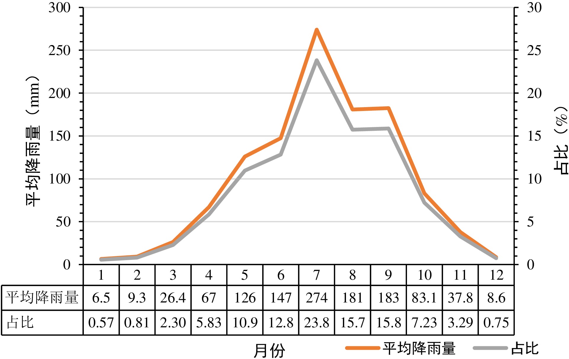
图 3 凉山州多年逐月平均降雨量统计图
Figure 3. Statistical map of monthly average precipitation in Liangshan Prefecture
![]()
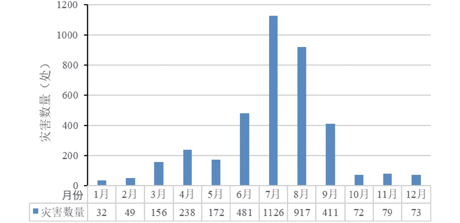
图 5 地质灾害新增数量多年分布特征
Figure 5. Distribution characteristics of the annual increase in the number of geological disasters over the years
![]()
图 6 不同类型灾害逐年新增数量统计
Figure 6. Statistics on the annual increase in the number of geological disasters of different types
![]()
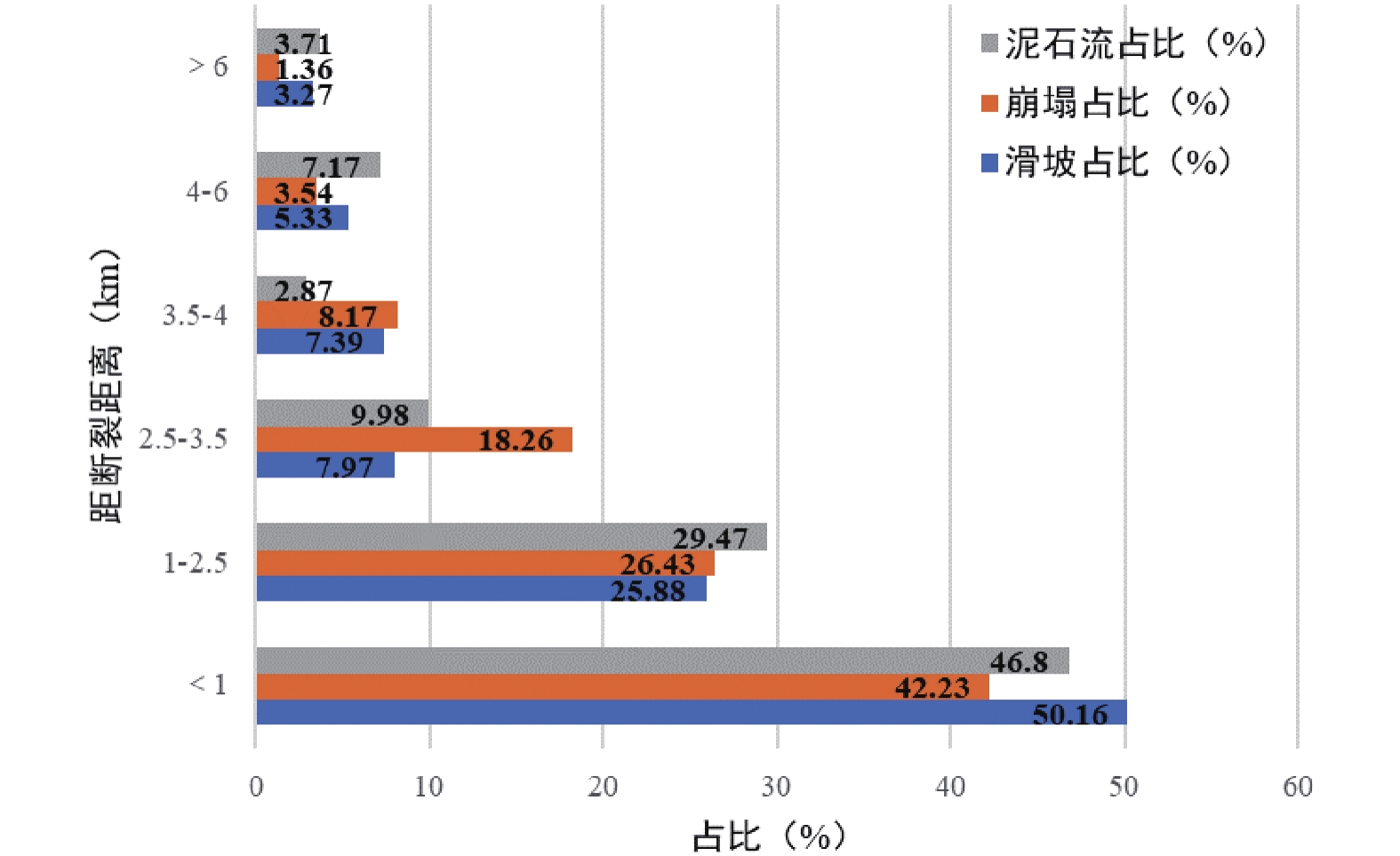
图 8 地质灾害占比与距断裂距离统计
Figure 8. Statistics of geological disasters and their distances from fractures
![]()
图 10 凉山州泥石流灾害分布图
Figure 10. Debris flow disaster distribution map in Liangshan Prefecture
表 1 凉山州地质灾害发育类型及数量
Table 1 Types and numbers of geological hazards in Liangshan Prefecture
规模 崩塌/处 滑坡/处 泥石流/处 地面塌陷/处 合计/处 占比/% 特大型 2 3 4 0 9 0.22% 大型 2 106 22 0 130 3.24% 中型 76 830 258 0 1164 28.98% 小型 169 1735 803 6 2713 67.55% 合计 249 2674 1087 6 4016 100% 占比 6.20% 66.58% 27.07% 0.15% 100%  下载: 导出CSV
表 2 凉山州地质灾害发育特征统计
Table 2 Characteristics of geological hazards in Liangshan Prefecture
灾害类型 发育特征 数量/处 占比/% 滑坡 土质 2950 98.40 岩质 48 1.60 崩塌 土质 13 4.09 岩质 305 95.91 泥石流 沟道型 1177 96.55 坡面型 42 3.45
下载: 导出CSV
表 3 凉山州各县(市)地质灾害分布基本情况统计表
Table 3 Statistical table of geological disaster distribution of counties and cities in Liangshan Prefecture
县(市) 面积/km2 崩塌/处 滑坡/处 泥石流/处 地面塌陷/处 合计/处 发育密度/(处/100 km2) 德昌县 2300 0 261 126 0 387 16.83 西昌市 2657 4 156 214 0 374 14.08 会东县 3225 7 312 16 0 335 10.39 会理市 4536 19 219 89 6 333 7.34 木里县 13223 16 238 74 0 328 2.48 宁南县 1672 5 238 53 0 296 17.70 雷波县 2840 65 155 34 0 254 8.94 美姑县 2515 9 157 58 0 224 8.91 金阳县 1587 23 121 57 0 201 12.67 甘洛县 2153 30 112 38 0 180 8.36 盐源县 8412 4 140 35 0 179 2.13 冕宁县 4422 6 56 95 0 157 3.55 昭觉县 2702 11 100 23 0 134 4.96 喜德县 2202 6 76 43 0 125 5.68 普格县 1905 4 60 52 0 116 6.09 越西县 2258 3 53 37 0 93 4.12 布拖县 1685 8 41 41 0 90 5.34
下载: 导出CSV
表 4 凉山州各水系地质灾害分布基本情况统计表
Table 4 Distribution of geological disasters in various water systems in Liangshan Prefecture
序号 名称 上级水系 面积/km2 滑坡/处 崩塌/处 泥石流/处 地面塌陷/处 灾害总数/处 密度/(处/100 km2) 1 理塘河流域 雅砻江 11165.5 155 3 31 0 189 1.69 2 安宁河流域 雅砻江 8536.50 368 10 401 0 779 9.13 3 美姑河流域 金沙江 4104.46 302 48 109 0 459 11.18 4 岷江流域 长江 434.84 5 0 1 0 6 1.38 5 尼日河流域 大渡河 4814.96 190 36 76 0 302 6.27 6 城河流域 金沙江 4088.36 269 18 92 6 385 9.42 7 鲹鱼河流域 金沙江 3137.32 250 9 11 0 270 8.61 8 西洛河流域 金沙江 4613.19 376 13 123 0 512 11.10 9 西溪河流域 金沙江 4399.98 196 26 84 0 306 6.96 10 西宁河流域 金沙江 1873.15 94 59 27 0 180 9.61 11 无量河流域 金沙江 4153.27 63 2 20 0 85 2.05 12 雅砻江流域 金沙江 9067.59 389 22 105 0 516 5.69
下载: 导出CSV
表 5 凉山州滑坡发育密度分区及特征
Table 5 Zoning and characteristics of landslide density in Liangshan Prefecture
滑坡发育密
度分区分区代号 所在行政区 分区面积/km2 主要诱发因素 极高密度区
(0.201~0.424处/km2)Ⅰ1 甘洛县中部 96 尼日河河谷侵蚀;甘洛–竹核断裂通过;红层软硬相间地层发育 Ⅰ2 美姑县中部 33 美姑河河谷侵蚀;红层软硬相间地层、含煤系地层发育 Ⅰ3 德昌县中南部 46 安宁河断裂带通过;板岩、千枚岩、花岗岩地层发育 Ⅰ4 宁南县南部、会东县北部 134 宁会断裂、则木河断裂、普渡河断裂交汇;红层软硬相间地层、白云岩发育;黑水河河谷侵蚀 高密度区
(0.083~0.201处/km2)Ⅱ1 甘洛县中部 565 尼日河河谷侵蚀;甘洛–竹核断裂通过;红层地层发育 Ⅱ2 美姑县中部、南部 102 美姑河河谷侵蚀;甘洛–竹核断裂、西河–美姑断裂通过;红层软硬相间地层、含煤系地层发育 Ⅱ3 雷波县东部 48 金沙江河谷侵蚀;雷波断裂通过;红层软硬相间地层、含煤系地层发育 Ⅱ4 喜德县中部 52 孙水河河谷侵蚀;红层软硬相间地层发育 Ⅱ5 金阳县中部南部 120 金沙江、西溪河河谷侵蚀;金阳断裂、莲峰断裂通过;红层软硬相间地层、千枚岩板岩发育 Ⅱ6 普格县中南部 64 西洛河河谷侵蚀;则木河断裂通过;红层软硬相间地层、含煤系地层发育 Ⅱ7 宁南县中部北部、会东县北部 66 宁会断裂、则木河断裂、普渡河断裂交汇;红层软硬相间地层、白云岩发育;黑水河河谷侵蚀 Ⅱ8 会东县西部、会理市南部 160 鲹鱼河河谷侵蚀;红层软硬相间地层、千枚岩板岩发育 Ⅱ9 会理市中部 84 安宁河断裂、宁会断裂通过;普隆河河谷侵蚀;红层软硬相间地层发育 Ⅱ10 西昌市西部、东部、南部 230 安宁河断裂、得力铺断裂、金河–箐河断裂、则木河断裂通过;安宁河、雅砻江河谷侵蚀;红层软硬相间地层发育;人类工程活动 Ⅱ11 德昌县中部西部、盐源县东南部 280 安宁河断裂、得力铺断裂、昔格达断裂带通过;安宁河、雅砻江河谷侵蚀;红层软硬相间地层、板岩、千枚岩、花岗岩地层发育 Ⅱ12 木里县南部 42 理塘河河谷侵蚀;板岩、千枚岩地层发育 Ⅱ13 昭觉县中部 37 西溪河河谷侵蚀;断裂通过;红层软硬相间地层、含煤系地层发育 Ⅱ14 会理市南部 60 城河河谷侵蚀;红层软硬相间地层发育 Ⅱ15 冕宁县西南部 27 雅砻江河谷侵蚀;红层软硬相间地层发育
下载: 导出CSV
表 6 凉山州崩塌发育密度分区及特征
Table 6 Zoning and characteristics of collapse density in Liangshan Prefecture
崩塌发育密度分区 分区代号 所在行政区 分区面积/km2 主要诱发因素 极高密度区(0.032~0.061处/km2) Ⅰ1 雷波县中部 1164 西宁河、金沙江、美姑河及支流河谷侵蚀;峨边–金阳断裂、雷波断裂通过;人类工程活动扰动;红层地层、白云岩灰岩发育 Ⅰ2 金阳县中部 184 西溪河、金沙江及支流河谷侵蚀;金阳断裂通过;人类工程活动扰动;红层地层、千枚岩页岩发育 高密度区(0.013~0.032处/km2) Ⅱ1 雷波县北部和东部 1052 西宁河、金沙江及支流河谷侵蚀;玛瑙断裂、峨边–金阳断裂、雷波断裂通过;人类工程活动扰动;红层地层、白云岩、灰岩发育 Ⅱ2 雷波县南部、昭觉县东部 677 美姑河及支流河谷侵蚀;峨边–金阳断裂通过;人类工程活动扰动;红层软硬相间地层、玄武岩白云岩发育 Ⅱ3 金阳县、布拖县东部 924 金沙江、西溪河及支流河谷侵蚀;莲峰断裂、金阳断裂通过;人类工程活动扰动;红层软硬相间地层、白云岩发育 Ⅱ4 金阳县南部、布拖县南部 627 金沙江及支流河谷侵蚀;乌库背斜东翼;人类工程活动扰动;红层软硬相间地层、页岩白云岩发育 Ⅱ5 甘洛县中部、北部 904 尼日河、大渡河及支流河谷侵蚀;汉源-甘洛断裂通过;人类工程活动扰动;玄武岩、碎屑岩、白云岩发育
下载: 导出CSV
表 7 凉山州泥石流发育密度分区及特征
Table 7 Zoning and characteristics of debris flow density in Liangshan Prefecture
泥石流发育密度分区 分区代号 所在行政区 分区面积/km2 主要诱发因素 极高密度区(0.112~0.255处/km2) Ⅰ1 西昌市东北角 235 安宁河及支流河谷侵蚀;安宁河断裂带通过;人类工程活动扰动 Ⅰ2 西昌市中东部 442 安宁河及支流河谷侵蚀;安宁河断裂、则木河断裂交汇通过;人类工程活动扰动;红层地层发育 高密度区(0.042~0.112处/km2) Ⅱ1 甘洛县中北部 158 尼日河及支流河谷侵蚀;汉源–甘洛断裂通过;人类工程活动扰动;红层地层发育 Ⅱ2 越西县中部 174 尼日河及支流河谷侵蚀;大凉山断裂通过;红层软硬相间地层发育 Ⅱ3 美姑县中部 504 美姑河及支流河谷侵蚀;西河–美姑断裂、甘洛–竹核断裂通过;红层软硬相间地层、含煤系地层发育 Ⅱ4 雷波县中部 69 金沙江及支流河谷侵蚀;峨边–金阳断裂通过;红层软硬相间地层发育 Ⅱ5 西昌市中部、中北、中南部 738 安宁河及支流河谷侵蚀;安宁河断裂、则木河断裂交汇通过;人类工程活动扰动;红层地层发育 Ⅱ6 布拖县南部 383 金沙江及支流河谷侵蚀;乌库背斜通过;红层软硬相间地层发育 Ⅱ7 普格县南部、宁南县中部 788 黑水河及支流河谷侵蚀;则木河断裂通过;红层软硬相间地层、千枚岩板岩发育 Ⅱ8 德昌县中部、中北—中南部 1305 安宁河及支流河谷侵蚀;安宁河断裂带通过;千枚岩板岩等地层发育 Ⅱ9 会理市中部、中北部 825 安宁河断裂通过;普隆河及支流河谷侵蚀;红层软硬相间地层、千枚岩板岩发育 Ⅱ10 冕宁县南部、喜德县西部 483 安宁河及支流河谷侵蚀;安宁河断裂通过;人类工程活动扰动;红层地层发育
下载: 导出CSV
-
[1] 白永健, 铁永波, 孟铭杰, 等, 2022. 川西地区地质灾害发育特征与时空分布规律[J]. 沉积与特提斯地质, 42(4): 666 − 674. Bai Y J, Tie Y B, Meng M J, et al., 2022. Characteristics and temporal-spatial distribution of geohazards in western Sichuan[J].Sedimentary Geology and Tethyan Geology, 42(4): 666 − 674.
[2] 白永健, 铁永波, 倪化勇, 等, 2014. 鲜水河流域地质灾害时空分布规律及孕灾环境研究[J]. 灾害学, 29(4): 69 − 75. Bai Y J, Tie Y B, Ni H Y, et al., 2014. Temporal-Spatial Distribution and Environment Pregnant of Geohazards in Xianshui River of Sichuan, China [J]. Journal of Catastrophology, 29(4): 69 − 75.
[3] 白永健, 倪化勇, 王德伟, 2014. 孙水河流域地质灾害时空分布及链式规律研究[J]. 工程地质学报, 22(s1): 156-163 Bai Y J, Ni H Y, Wang D W, 2014. Research on the Space-Time Distribution and Chain Patterns of Geohazards in SunShui river[J]. Journal of Engineering Geology, 22(s1): 156-163.
[4] 陈波, 2017. 喜德县波振沟泥石流形成条件及动力特征[J]. 四川地质学报, 37(3): 486-489 Chen B, 2017. Genesis and Dynamics of the Bozhen’gou Debris Flow in Xide, Sichuan[J]. Acta Geologica Sichuan, 37(3): 486-489.
[5] 常晓军, 丁俊, 魏伦武, 等, 2008. 四川安宁河流域地质灾害发育分布规律浅析[J]. 地质学报, 28(1): 35 − 40. Chang X J, Ding J, Wei L W, et al., 2008. Development of Geological Hazards in the Anning River Valley, Sichuan[J]. Acta Geologica Sinica, 28(1): 35 − 40.
[6] Fan X, Scaringi G, Korup O, et al. , 2019. Earthquake-induced chains of geologic hazards: patterns, mechanisms, and impacts [J]. Reviews of Geophysics, 57: 421-503. DOI: 10.1029/2018RG000626
[7] Huang R Q, Fan X M, 2013. The landslide story[J]. Nature Geoscience, 6: 325-326. DOI: 10.1038/ngeo1806
[8] 黄靖, 第宝锋, 边静虹, 等, 2014. 凉山州山地灾害空间分布特征及人为驱动力分析[J]. 水土保持研究, 21(6): 278-283 Huang J, Di B F, Bian J H, et al. , 2014. Analysis on the Spatial Distribution Characteristics and Human Driving Forces of Mountain Hazardls in Liangshan Prefecture[J]. Research of Soil and Water Conservation, 21(6): 278-283.
[9] 吉日伍呷, 田宏岭, 刘雅琴, 2022. 喜德县“6.4”山火泥石流灾害特征与防治建议[J]. 科学技术与工程, 22(17): 6880-6887 Ji R W G, Tian H L, Liu Y Q, 2022. Characteristics of the“6.4”forest fire-induced debris flow in Xide County and disaster preventing advices [J]. Science Technology and Engineering, 22(17): 6880-6887.
[10] 李傲, 2018. 会理县美女沟泥石流发育特征及防治方案研究[D]. 长春: 吉林大学. Li A, 2018. Characteristics Analysis and Provention Study on Meinv Debris-flow Disaster in Lihui County, Sichuan Province[D]. Changchun: Jilin University.
[11] 雷鸣宇, 崔一飞, 倪钧钧, 等, 2021. 浅层滑坡型火后泥石流起动机理研究进展与案例分析[J]. 工程地质学报, 29(3): 786-797 Lei M Y, Cui Y F, Ni J J, et al. , 2021. Actuality and case study on mechanism of post-fire debris flow initiated by shallow landslide[J]. Journal of Engineering Geology, 29(3): 786-797.
[12] 刘洪, 黄瀚霄, 欧阳渊, 等, 2020. 基于地质建造的土壤地质调查及应用前景分析-以大凉山区西昌市为例[J]. 沉积与特提斯地质, 40(1): 91-105 Liu H, Huang H X, OUYANG Y, et al. , 2020. Soil’s geologic investigation in Daliangshan, Xichang, Sichuan[J]. Sedimentary Geology and Tethyan Geology, 40(1): 91-105.
[13] 刘洪, 黄瀚霄, 欧阳渊, 等, 2021. 新构造活动的生态地质环境效应讨论——以扬子西缘西昌市为例[J].中国地质调查, 8(6): 63 − 77. Liu H, Huang H X, Ouyang Y, et al., 2021. Discussion on the eco-geo-environment effects of Neotectonic activities: A case study of Xichang City in western Yangtze block[J].Geological Survey of China, 8(6): 63 − 77(in Chinese with English abstract).
[14] 刘洪, 李文昌, 欧阳渊, 等, 2023. 基于地质建造的西南山区生态地质编图探索与实践——以邛海—泸山地区为例[J]. 地质学报, 97(2): 623 − 638. Liu H, Li W C, Ouyang Y, et al., 2023. Exploration and ractice of the compilation of ecological geology series maps based on Geological Formations research, mountainous region in Southwest China ——exemplified by Qionghai-Lushan area, western margin of Yangtze Block[J].Acta Geologica Sinica, 97(2): 623 − 638. (in Chinese with English abstract).
[15] Liu H, Li W C, Liu H, et al., 2022. Petrogenesis and tectonic implications of Maoniushan monzogranites in the western margin of the Yangtze Block, Southwest China: Constraints from geochemistry, zircon U–Pb geochronology, and Hf–Nd–Sr isotopes[J]. Geological Journal, 57: 1638–1657.
[16] 刘锋, 张茂省, 董英, 等, 2023. 基于1984~2022 年榆林市地质灾害记录对其时空分布规律分析[J]. 西北地质, 56(3): 204-213 DOI: 10.12401/j.nwg.2023102 Liu F, Zuang M S, Dong Y, et al. , 2023. Analysis of Spatial and Temporal Distribution of Geological Disasters in Yulin City Based on the Records from 1984 to 2022[J]. Northwestern Geology, 56(3): 204-213. DOI: 10.12401/j.nwg.2023102
[17] Li T, Li Y G, Liu H, et al., 2023. Spatial distribution and ecological risk assessment of heavy metal elements in rock-soil in the mountainous areas of Southwest China: A case study of Xichang[J].Geological Journal, 58(10):3866−3878https: //doi.org/10.1002/gj.4814.
[18] 马成兵, 唐得胜, 肖宇月, 等, 2022. 攀枝花市地质灾害发育规律与防灾减灾对策研究[J]. 中国地质调查, 9(4): 37-44 Ma C B, Tang D S, Xiao Y Y, et al. , 2022. Study on the development law of geological disasters and the countermeasures of disaster prevention and reduction in Panzhihua City[J]. Geological Survey of China, 9(4): 37-44.
[19] 倪化勇, 王德伟, 白永健, 等, 2016. 孙水河流域地质灾害链类型结构与断链对策[J]. 山地学报, 34(4): 451-459 Ni H Y, Wang D W, Bai Y J, et al. , 2016. Structure Type and Countermeasures of Geo-hazard Chain Effects in Sunshui River Drainage, Sichuan, China[J]. Mountain Research, 34(4): 451-459.
[20] 秦宇龙, 吴建亮, 詹涵钰, 等, 2021. 川西甘孜地区活动断裂与地质灾害分布相关性探讨[J]. 地质力学学报, 27(3): 463-474 Qin Y L, Wu J L, Zhan H Y, et al. , 2021. Discussion on the correlation between active fault andgeological disaster distribution in the Ganzi area, western Sichuan province, China [J]. Journal ofGeomechanics, 27(3): 463-474.
[21] Tang C, van Asch T W J, Chang M, et al., 2012. Catastrophic debris flows on 13 August 2010 in the Qingping area, southwestern China: the combined effects of a strong earthquake and subsequent rainstorms[J]. Geomorphology, 139: 559 − 576.
[22] 铁永波, 徐如阁, 刘洪, 等, 2020. 西昌市泸山地区典型火后泥石流特征与成因机制研究-以响水沟左岸3#支沟为例[J]. 中国地质调查, 7(3): 82-88 Tie Y B, Xu R G, Liu H, et al. , 2020. Study on the characteristics and formation mechanism of the typical post-fire debris flow in Lushan area of Xichang City: A case study of 3# branch on the left bank of Xiangshuigou[J]. Geological Survey of China, 7(3): 82-88.
[23] 铁永波, 葛华, 高延超, 等, 2022. 二十世纪以来西南地区地质灾害研究历程与展望[J]. 沉积与特提斯地质, 42(4): 653 − 665. Tie Y B, Ge H, Gao Y C, et al., 2022. The research progress and prospect of geological hazards in Southwest China since the 20 th Century[J]. Sedimentary Geology and Tethyan Geology, 42( 4): 653 − 665.
[24] 吴莉娟, 2012. 凉山州强降雨型泥石流灾害预报预警研究[D]. 成都: 成都信息工程学院. Wu L J, 2012. A Research on the Forecast & Early Warning for the Heavy Rain Type Debris Flows in Liangshan[D]. Chengdu: Chengdu University of Information Technology.
[25] 伍吉仓, 王岩, 吴伟伟, 2018. 青藏高原东南缘现今地壳运动速度场分析[J]. 大地测量与地球动力学, 38(2): 116-124 DOI: 10.14075/j.jgg.2018.02.002 Wu J C, Wang Y, Wu W W, 2018. Analysis of Current Crustal Movement Velocity Field of South-Eastern Tibetan Plateau[J]. Journal of Geodesy and Geodynamics, 38(2): 116-124. DOI: 10.14075/j.jgg.2018.02.002
[26] 姚鑫, 李凌婧, 张永双, 等, 2015. 青藏高原东缘区域地壳稳定性评价[J]. 地质通报, 34(1): 32 − 44 Yao X, Li L J, Zhang Y S, et al., 2015. Regional crustal stability assessment of the eastern margin of Tibetan Plateau [J]. Geological Bulletin of China, 34(1): 32 − 44.
[27] Yin Y P, Wang W P. Zhang N. et al. , 2017. The June 2017 Maoxian landslide: Geological disaster in an earthquake area after the Wenchuan Ms 8.0 earthquake [J]. Science China Technological Sciences, 60(11): 1762 -1766. DOI: 10.1007/s11431-017-9148-2
[28] 杨柳青, 陈容, 贺拿, 等, 2023. 四川凉山州冕宁县彝海镇“6·26”大型泥石流成因分析[J]. 中国地质灾害与防治学报, 34(1): 94-101 Yang L Q, Chen R, He N, et al, 2023l. Analysis of the cause of the “6·26“ large debris flow in Yihai Town, Mianning County, Liangshan Prefecture, Sichuan Province[J]. The Chinese Journal of Geological Hazard and Control, 34(1): 94-101.
[29] 杨相斌, 胡卸文, 曹希超, 等, 2022. 四川西昌电池厂沟火后泥石流成灾特征及防治措施分析[J]. 中国地质灾害与防治学报, 33(4): 1-8 Yang X B, Hu X W, Cao X C, et al. , 2022. Analysis on disaster characteristics and prevention measures of the post-fire debris flow in Dianchichang gully, Xichang of Sichuan Province[J]. The Chinese Journal of Geological Hazard and Control, 33(4): 1-8.
[30] 张楠, 徐永强, 2013. 四川宁南县白鹤滩6·28泥石流特征分析[J]. 中国地质灾害与防治学报, 24(4): 66-70 Zhang N, Xu Y Q, 2013. Hazard survey on 6·28 debris flow of Baihetan, Ningnan County, Sichuan Province[J]. The Chinese Journal of Geological Hazard and Control, 24(4): 66-70.
[31] 张瑞端, 2014. 安宁河断裂带发育特征与地质灾害效应研究[D]. 北京: 中国地质大学(北京). Zhang R D, 2014. Development Characteristics and Geo-hazard Effect of Anninghe Fault Zone[D]. Beijing: China University of Geosciences (Beijing).
[32] 张慈, 赵银兵, 欧阳渊, 等, 2023. 青藏高原东缘地质环境对植被覆盖度的影响研究: 以冕宁县为例[J]. 沉积与特提斯地质, 43(3): 604 − 614. Zhang C, Zhao Y B, Ouyang Y, et al., 2021. Influence of geological environment on vegetation coverage in the eastern edge of Qinghai-Tibet Plateau: A case study of Mianning[J]. Sedimentary Geology and Tethyan Geology. https: //doi.org/10.19826/j.cnki.1009-3850.2021.03010


计量
- 文章访问数: 124
- HTML全文浏览量: 11
- PDF下载量: 69
